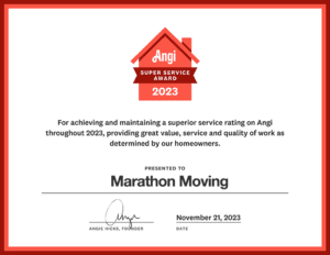
Allied - Marathon Moving in Boston MA
Stay Connected:

FIND OUT WHY WE'RE The #1

Boston to California MOVERS

Marathon Moving is a local moving company with movers who cater to customer needs with safety & professionalism

Welcome to Marathon Moving Co.

Moving Services We Provide

Residential Moving ⮞

Residential Movers

As a top residential moving company, Marathon has everything you need to make your family's move a breeze!
Get a Quote ⮞

Commercial Moving ⮞

Commercial Movers

It takes skill and a lot of effort to move your business. For your commercial move, only trust the best!
Get a Quote ⮞

Interstate Moving ⮞

Interstate Movers

Marathon Moving has been a leading interstate moving company for years. Our out of state movers offer the experience to give you a pleasant move..
Get a Quote ⮞
Best Mover Rates in Beverly MA
Play Video about Best Mover Rates in Beverly MA

Our Moving Promise

Marathon's Offer

Here at Marathon Moving, we are dedicated to every move and to our client’s needs. Our team of Boston to California movers are committed to you and your move. Our main goal is to give you a hassle-free moving experience.

Our moving process

Moving Is Easy

Book our service ⮞

We pack your goods ⮞

We move your goods ⮞

We unpack your goods ⮞

Customer-centric relocation services

Our Moving Services

We can recommend our packing services as part of a full-service move. We’ll make sure you’re ready to go before your moving day arrives.

Marathon moving company offers professional warehouse spaces and independent security guards to both residential and commercial movers.

Our expert staff can make sure that your new home or the one you’re leaving gets free moving and packing advice from an on-site appointment.

Our moving company offers a full range of valuation and insurance services to make your move as painless and successful as possible.

Moving looks difficult?

Have a
question?

Our Testimonials

Moving Clients

We are Ready to Help You

Frequently Asked Moving Questions

Boston to California Movers

Marathon Moving , we aim to remove whatever apprehensions you have about interstate moving and the stress that comes with it. We achieve our aim through careful attention to detail and planning tailored specifically for each client. This way, we ensure that all of your needs and requests regarding the moving process are met.

Boston to California Moving Services

Moving is a process that most of us experience at some point in our lives. Thus, our team of movers believes that excellent service should cost you a fortune. Everyone should be able to have access to professional movers that transport their things safely and timely.

Local & Long Distance Movers

At Marathon Moving, we have made that possible by pricing our services to market-competitive levels without compromising our service quality. Our determination to innovative technology, methods, and equipment acquisition has allowed us to keep costs down while simultaneously improving the service quality.

Boston to California Resources:

  • Boston or California
  • Concord NH Zip Codes
  • Map of Concord NH Area
  • Concord NH Information Bureau
  • Concord New Hampshire Wiki Page

Meet our dedicated team

Our Moving Team

Marathon Moving - Paul & Gail

Paul & Gail Nelson

Owners of Marathon Moving

Marathon Moving - Boston Moving Consultant Donny

Donald Reardon

Warehouse Manager

Marathon Moving - Boston Moving Consultant Lillian

Lillian Downes

Move Coordinator

Marathon Moving - Boston Moving Consultant Sheila

Sheila Winters

Office Manager

Take the stress out of moving! View our mover’s guide!

Latest News

Blog Posts

Any question at

781-300-3200

Boston to California

United States

Monday-Friday

8AM–5PM

Send your mail at

info@marathonmoving.com

Marathon Moving Tips and Resources

Our Resources

Additional Moving Resources

We know that moving is stressful enough. To make it as simple and painless as possible, we have provided additional resources to help you.

Let's Get You A Free Quote

Before and after-sales services mean a lot to our moving company. Thus, we have a friendly staff that will help you every step of the way. Ready to secure moving services from Boston to California? Call Marathon Moving at  781-300-3200.

Boston From Wikipedia, the free encyclopedia Jump to navigationJump to search This article is about the city in the US state of Massachusetts. For the town in England which the city is named after, see Boston, Lincolnshire. For other uses, see Boston (disambiguation). Boston, Massachusetts State capital city City of Boston Downtown Boston from the Boston Harbor Brick rowhouses along Acorn Street Old State House Massachusetts State House Fenway Park ballgame at night Boston skyline from Charles River From top, left to right: Downtown (from the Boston Harbor); Acorn Street on Beacon Hill; Old State House; Massachusetts State House; Fenway Park ballgame; Back Bay (from the Charles River) Flag of Boston, Massachusetts Flag Official seal of Boston, Massachusetts Seal Official logo of Boston, Massachusetts Logo Nickname(s): See Nicknames of Boston Motto(s): Sicut patribus sit Deus nobis (Latin) 'As God was with our fathers, so may He be with us' Wikimedia | © OpenStreetMap Wikimedia | © OpenStreetMap Interactive maps of Boston Coordinates: 42°21′37″N 71°03′28″WCoordinates: 42°21′37″N 71°03′28″W Country United States Region New England State Massachusetts County Suffolk Historic countries Kingdom of England Commonwealth of England Kingdom of Great Britain Historic colonies Massachusetts Bay Colony, Dominion of New England, Province of Massachusetts Bay Settled 1625 Incorporated (town) September 7, 1630 (date of naming, Old Style)[a] Incorporated (city) March 19, 1822 Named for Boston, Lincolnshire Government • Type Strong mayor / Council • Mayor Michelle Wu (D) • Council Boston City Council • Council President Edward M. Flynn (D) Area[1] • State capital city 89.61 sq mi (232.10 km2) • Land 48.34 sq mi (125.20 km2) • Water 41.27 sq mi (106.90 km2) • Urban 1,770 sq mi (4,600 km2) • Metro 4,500 sq mi (11,700 km2) • CSA 10,600 sq mi (27,600 km2) Elevation 141 ft (43 m) Population (2020) • State capital city 675,647 • Rank 24th in the United States 1st in Massachusetts • Density 13,976.98/sq mi (5,396.51/km2) • Metro[2] 4,941,632 (10th) Demonym(s) Bostonian Time zone UTC−5 (EST) • Summer (DST) UTC−4 (EDT) ZIP Codes 53 ZIP Codes[3] Area codes 617 and 857 FIPS code 25-07000 GNIS feature ID 617565 Primary Airport Logan International Airport Interstates I-90.svg I-93.svg Commuter Rail MBTA Commuter Rail Rapid Transit MBTA subway Website Boston.gov Boston (US: /ˈbɔːstən/, UK: /ˈbɒstən/),[4] officially the City of Boston, is the capital and most populous city of the Commonwealth of Massachusetts in the United States and 24th-most populous city in the country.[5] The city proper covers about 48.4 sq mi (125 km2)[6] with a population of 675,647 in 2020,[7] also making it the most populous city in New England.[8] It is the seat of Suffolk County (although the county government was disbanded on July 1, 1999).[9] The city is the economic and cultural anchor of a substantially larger metropolitan area known as Greater Boston, a metropolitan statistical area (MSA) home to a census-estimated 4.8 million people in 2016 and ranking as the tenth-largest MSA in the country.[10] A broader combined statistical area (CSA), generally corresponding to the commuting area[11] and including Providence, Rhode Island, is home to some 8.2 million people, making it the sixth most populous in the United States.[12] Boston is one of the oldest municipalities in the United States, founded on the Shawmut Peninsula in 1630 by Puritan settlers from the English town of the same name.[13][14] It was the scene of several key events of the American Revolution, such as the Boston Massacre, the Boston Tea Party, the Battle of Bunker Hill, and the siege of Boston. Upon American independence from Great Britain, the city continued to be an important port and manufacturing hub as well as a center for education and culture.[15][16] The city has expanded beyond the original peninsula through land reclamation and municipal annexation. Its rich history attracts many tourists, with Faneuil Hall alone drawing more than 20 million visitors per year.[17] Boston's many firsts include the United States' first public park (Boston Common, 1634), first public or state school (Boston Latin School, 1635)[18] first subway system (Tremont Street subway, 1897),[19] and first large public library (Boston Public Library, 1848). Today, Boston is a thriving center of scientific research. The Boston area's many colleges and universities, notably Harvard and MIT, make it a world leader in higher education,[20] including law, medicine, engineering and business, and the city is considered to be a global pioneer in innovation and entrepreneurship, with nearly 5,000 startups.[21][22][23] Boston's economic base also includes finance,[24] professional and business services, biotechnology, information technology and government activities.[25] Households in the city claim the highest average rate of philanthropy in the United States;[26] businesses and institutions rank among the top in the country for environmental sustainability and investment.[27] Contents 1 History 1.1 Indigenous peoples 1.2 Colonial 1.3 Revolution and the siege of Boston 1.4 Post-revolution and the War of 1812 1.5 19th century 1.6 20th century 1.7 21st century 2 Geography 2.1 Neighborhoods 2.2 Climate 2.3 Cityscapes 3 Demographics 3.1 Ancestry 3.2 Demographic breakdown by ZIP Code 3.2.1 Income 3.3 Religion 4 Economy 5 Education 5.1 Primary and secondary education 5.2 Higher education 6 Public safety 7 Culture 8 Environment 8.1 Pollution control 8.2 South Boston Sustainable Housing 8.3 Water purity and availability 8.4 Climate change and sea level rise 9 Sports 10 Parks and recreation 11 Government and politics 12 Media 12.1 Newspapers 12.2 Radio and television 12.3 Film 12.4 Video games 13 Healthcare 14 Infrastructure 14.1 Transportation 15 International relations 16 See also 17 Notes 18 References 18.1 Citations 18.2 Sources 19 Further reading 20 External links History Main article: History of Boston For a chronological guide, see Timeline of Boston. Indigenous peoples Prior to European colonization, modern-day Boston was originally inhabited by the indigenous Massachusett.[28][29] There were small Native communities throughout what became Boston, who likely moved between winter homes inland along the Charles River (called Quinobequin, meaning "meandering," by the Native people), where hunting was plentiful and summer homes along the coast where fishing and shellfish beds were plentiful.[28][29][30] Through archeological excavations, one of the oldest Native fishweirs in New England was found on Boylston Street. Native people constructed it to trap fish several thousand years ago.[29] Colonial Boston's early European settlers had first called the area Trimountaine (after its "three mountains", only traces of which remain today) but later renamed it Boston after Boston, Lincolnshire, England, the origin of several prominent colonists. The renaming on September 7, 1630 (Old Style),[31][b] was by Puritan colonists from England[14][32] who had moved over from Charlestown earlier that year in quest for fresh water. Their settlement was initially limited to the Shawmut Peninsula, at that time surrounded by the Massachusetts Bay and Charles River and connected to the mainland by a narrow isthmus. The peninsula is thought to have been inhabited as early as 4000 BCE.[33] In 1629, the Massachusetts Bay Colony's first governor John Winthrop led the signing of the Cambridge Agreement, a key founding document of the city. Puritan ethics and their focus on education influenced its early history;[34] America's first public school, Boston Latin School, was founded in Boston in 1635.[18] John Hull and the pine tree shilling played a central role in the establishment of the Massachusetts Bay Colony and the Old South Church in the 1600s. In 1652 the Massachusetts legislature authorized John Hull to produce coinage. "The Hull Mint produced several denominations of silver coinage, including the pine tree shilling, for over 30 years until the political and economic situation made operating the mint no longer practical."[35] King Charles II for reasons which were mostly political deemed the "Hull Mint" high treason which had a punishment of being hanged, drawn and quartered. "On April 6, 1681, Edward Randolph petitioned the king, informing him the colony was still pressing their own coins which he saw as high treason and believed it was enough to void the charter. He asked that a writ of Quo warranto (a legal action requiring the defendant to show what authority they have for exercising some right, power, or franchise they claim to hold) be issued against Massachusetts for the violations."[36] Boston was the largest town in the Thirteen Colonies until Philadelphia outgrew it in the mid-18th century.[37] Boston's oceanfront location made it a lively port, and the city primarily engaged in shipping and fishing during its colonial days. However, Boston stagnated in the decades prior to the Revolution. By the mid-18th century, New York City and Philadelphia surpassed Boston in wealth. During this period, Boston encountered financial difficulties even as other cities in New England grew rapidly.[38][39] Revolution and the siege of Boston Main articles: Boston campaign and Siege of Boston In 1773, a group of angered Bostonian citizens threw a shipment of tea by the East India Company into Boston Harbor as a response to the Tea Act, in an event known as the Boston Tea Party. The weather continuing boisterous the next day and night, giving the enemy time to improve their works, to bring up their cannon, and to put themselves in such a state of defence, that I could promise myself little success in attacking them under all the disadvantages I had to encounter. William Howe, 5th Viscount Howe, in a letter to William Legge, 2nd Earl of Dartmouth, about the British army's decision to leave Boston, dated March 21, 1776.[40] Map of Boston in 1775 Map showing a British tactical evaluation of Boston in 1775. Many of the crucial events of the American Revolution[41] occurred in or near Boston. Boston's penchant for mob action along with the colonists' growing lack of faith in either Britain or its Parliament fostered a revolutionary spirit in the city.[38] When the British parliament passed the Stamp Act in 1765, a Boston mob ravaged the homes of Andrew Oliver, the official tasked with enforcing the Act, and Thomas Hutchinson, then the Lieutenant Governor of Massachusetts.[38][42] The British sent two regiments to Boston in 1768 in an attempt to quell the angry colonists. This did not sit well with the colonists. In 1770, during the Boston Massacre, British troops shot into a crowd that had started to violently harass them. The colonists compelled the British to withdraw their troops. The event was widely publicized and fueled a revolutionary movement in America.[39] In 1773, Parliament passed the Tea Act. Many of the colonists saw the act as an attempt to force them to accept the taxes established by the Townshend Acts. The act prompted the Boston Tea Party, where a group of angered Bostonian citizens threw an entire shipment of tea sent by the East India Company into Boston Harbor. The Boston Tea Party was a key event leading up to the revolution, as the British government responded furiously with the Coercive Acts, demanding compensation for the destroyed tea from the Bostonians.[38] This angered the colonists further and led to the American Revolutionary War. The war began in the area surrounding Boston with the Battles of Lexington and Concord.[38][43] Boston itself was besieged for almost a year during the siege of Boston, which began on April 19, 1775. The New England militia impeded the movement of the British Army. Sir William Howe, then the commander-in-chief of the British forces in North America, led the British army in the siege. On June 17, the British captured the Charlestown peninsula in Boston, during the Battle of Bunker Hill. The British army outnumbered the militia stationed there, but it was a pyrrhic victory for the British because their army suffered irreplaceable casualties. It was also a testament to the skill and training of the militia, as their stubborn defence made it difficult for the British to capture Charlestown without suffering further irreplaceable casualties.[44][45] Several weeks later, George Washington took over the militia after the Continental Congress established the Continental Army to unify the revolutionary effort. Both sides faced difficulties and supply shortages in the siege, and the fighting was limited to small-scale raids and skirmishes. The narrow Boston Neck, which at that time was only about a hundred feet wide, impeded Washington's ability to invade Boston, and a long stalemate ensued. A young officer, Rufus Putnam, came up with a plan to make portable fortifications out of wood that could be erected on the frozen ground under cover of darkness. Putnam supervised this effort, which successfully installed both the fortifications and dozens of cannon on Dorchester Heights that Henry Knox had laboriously brought through the snow from Fort Ticonderoga. The astonished British awoke the next morning to see a large array of cannons bearing down on them. General Howe is believed to have said that the Americans had done more in one night than his army could have done in six months. The British Army attempted a cannon barrage for two hours, but their shot could not reach the colonists' cannons at such a height. The British gave up, boarded their ships and sailed away. Boston still celebrates "Evacuation Day" each year. Washington was so impressed, he made Rufus Putnam his chief engineer.[43][44][46] Post-revolution and the War of 1812 Boston, as the Eagle and the Wild Goose See It, 1860, by J.W. Black, the first recorded aerial photograph After the Revolution, Boston's long seafaring tradition helped make it one of the nation's busiest ports for both domestic and international trade. Boston's harbor activity was significantly curtailed by the Embargo Act of 1807 (adopted during the Napoleonic Wars) and the War of 1812. Foreign trade returned after these hostilities, but Boston's merchants had found alternatives for their capital investments in the interim. Manufacturing became an important component of the city's economy, and the city's industrial manufacturing overtook international trade in economic importance by the mid-19th century. A network of small rivers bordering the city and connecting it to the surrounding region facilitated shipment of goods and led to a proliferation of mills and factories. Later, a dense network of railroads furthered the region's industry and commerce.[47] State Street, 1801 During this period, Boston flourished culturally, as well, admired for its rarefied literary life and generous artistic patronage,[48][49] with members of old Boston families—eventually dubbed Boston Brahmins—coming to be regarded as the nation's social and cultural elites.[50] They are often associated with the American upper class, Harvard University;[51] and the Episcopal Church.[52][53] Boston was an early port of the Atlantic triangular slave trade in the New England colonies, but was soon overtaken by Salem, Massachusetts and Newport, Rhode Island.[54] Boston eventually became a center of the abolitionist movement.[55] The city reacted strongly to the Fugitive Slave Act of 1850,[56] contributing to President Franklin Pierce's attempt to make an example of Boston after the Anthony Burns Fugitive Slave Case.[57][58] In 1822,[15] the citizens of Boston voted to change the official name from the "Town of Boston" to the "City of Boston", and on March 19, 1822, the people of Boston accepted the charter incorporating the city.[59] At the time Boston was chartered as a city, the population was about 46,226, while the area of the city was only4.8 sq mi (12 km2).[59] 19th century Painting with a body of water with sailing ships in the foreground and a city in the background View of downtown Boston from Dorchester Heights, 1841 Tremont Street, 1843 In the 1820s, Boston's population grew rapidly, and the city's ethnic composition changed dramatically with the first wave of European immigrants. Irish immigrants dominated the first wave of newcomers during this period, especially following the Great Famine; by 1850, about 35,000 Irish lived in Boston.[60] In the latter half of the 19th century, the city saw increasing numbers of Irish, Germans, Lebanese, Syrians,[61] French Canadians, and Russian and Polish Jews settling in the city. By the end of the 19th century, Boston's core neighborhoods had become enclaves of ethnically distinct immigrants with their residence yielding lasting cultural change. Italians became the largest inhabitants of the North End,[62] Irish dominated South Boston and Charlestown, and Russian Jews lived in the West End. Irish and Italian immigrants brought with them Roman Catholicism. Currently, Catholics make up Boston's largest religious community,[63] and the Irish have played a major role in Boston politics since the early 20th century; prominent figures include the Kennedys, Tip O'Neill, and John F. Fitzgerald.[64] Between 1631 and 1890, the city tripled its area through land reclamation by filling in marshes, mud flats, and gaps between wharves along the waterfront.[65] The largest reclamation efforts took place during the 19th century; beginning in 1807, the crown of Beacon Hill was used to fill in a 50-acre (20 ha) mill pond that later became the Bulfinch Triangle and Haymarket Square. The present-day State House sits atop this lowered Beacon Hill. Reclamation projects in the middle of the century created significant parts of the South End, the West End, the Financial District, and Chinatown. The Old City Hall was home to the Boston city council from 1865 to 1969. General view of Boston, by J. J. Hawes, c. 1860s–1880s Colored print image of a city square in the 1900s Haymarket Square, 1909 After the Great Boston fire of 1872, workers used building rubble as landfill along the downtown waterfront. During the mid-to-late 19th century, workers filled almost 600 acres (240 ha) of brackish Charles River marshlands west of Boston Common with gravel brought by rail from the hills of Needham Heights. The city annexed the adjacent towns of South Boston (1804), East Boston (1836), Roxbury (1868), Dorchester (including present-day Mattapan and a portion of South Boston) (1870), Brighton (including present-day Allston) (1874), West Roxbury (including present-day Jamaica Plain and Roslindale) (1874), Charlestown (1874), and Hyde Park (1912).[66][67] Other proposals were unsuccessful for the annexation of Brookline, Cambridge,[68] and Chelsea.[69][70] 20th century Fenway Park, home of the Boston Red Sox, opened in 1912.[71] Many architecturally significant buildings were built during these early years of the 20th century: Horticultural Hall,[72] the Tennis and Racquet Club,[73] Isabella Stewart Gardner Museum,[74] Fenway Studios,[75] Jordan Hall,[76] and the Boston Opera House. The Longfellow Bridge,[77] built in 1906, was mentioned by Robert McCloskey in Make Way for Ducklings, describing its "salt and pepper shakers" feature.[78] Logan International Airport opened on September 8, 1923.[79] The Boston Bruins were founded in 1924 and played their first game at Boston Garden in November 1928.[80] Boston went into decline by the early to mid-20th century, as factories became old and obsolete and businesses moved out of the region for cheaper labor elsewhere.[81] Boston responded by initiating various urban renewal projects, under the direction of the Boston Redevelopment Authority (BRA) established in 1957. In 1958, BRA initiated a project to improve the historic West End neighborhood. Extensive demolition was met with strong public opposition, and thousands of families were displaced.[82] The BRA continued implementing eminent domain projects, including the clearance of the vibrant Scollay Square area for construction of the modernist style Government Center. In 1965, the Columbia Point Health Center opened in the Dorchester neighborhood, the first Community Health Center in the United States. It mostly served the massive Columbia Point public housing complex adjoining it, which was built in 1953. The health center is still in operation and was rededicated in 1990 as the Geiger-Gibson Community Health Center.[83] The Columbia Point complex itself was redeveloped and revitalized from 1984 to 1990 into a mixed-income residential development called Harbor Point Apartments.[84] By the 1970s, the city's economy had begun to recover after 30 years of economic downturn. A large number of high-rises were constructed in the Financial District and in Boston's Back Bay during this period.[85] This boom continued into the mid-1980s and resumed after a few pauses. Hospitals such as Massachusetts General Hospital, Beth Israel Deaconess Medical Center, and Brigham and Women's Hospital lead the nation in medical innovation and patient care. Schools such as the Boston Architectural College, Boston College, Boston University, the Harvard Medical School, Tufts University School of Medicine, Northeastern University, Massachusetts College of Art and Design, Wentworth Institute of Technology, Berklee College of Music, the Boston Conservatory, and many others attract students to the area. Nevertheless, the city experienced conflict starting in 1974 over desegregation busing, which resulted in unrest and violence around public schools throughout the mid-1970s.[86] 21st century Back Bay neighborhood Boston is an intellectual, technological, and political center but has lost some important regional institutions,[87] including the loss to mergers and acquisitions of local financial institutions such as FleetBoston Financial, which was acquired by Charlotte-based Bank of America in 2004.[88] Boston-based department stores Jordan Marsh and Filene's have both merged into the New York City–based Macy's.[89] The 1993 acquisition of The Boston Globe by The New York Times[90] was reversed in 2013 when it was re-sold to Boston businessman John W. Henry. In 2016, it was announced General Electric would be moving its corporate headquarters from Connecticut to the Seaport District in Boston, joining many other companies in this rapidly developing neighborhood. Boston has experienced gentrification in the latter half of the 20th century,[91] with housing prices increasing sharply since the 1990s.[92] On April 15, 2013, two Chechen Islamist brothers detonated a pair of bombs near the finish line of the Boston Marathon, killing three people and injuring roughly 264.[93] In 2016, Boston briefly shouldered a bid as the US applicant for the 2024 Summer Olympics. The bid was supported by the mayor and a coalition of business leaders and local philanthropists, but was eventually dropped due to public opposition.[94] The USOC then selected Los Angeles to be the American candidate with Los Angeles ultimately securing the right to host the 2028 Summer Olympics.[95] Geography Aerial view of the Boston area from space Boston as seen from ESA Sentinel-2. Boston Harbor, at the center, has made Boston a major shipping port since its founding. Boston has an area of 89.63 sq mi (232.1 km2)—48.4 sq mi (125.4 km2) (54%) of land and41.2 sq mi (106.7 km2) (46%) of water. The city's official elevation, as measured at Logan International Airport, is 19 ft (5.8 m) above sea level.[96] The highest point in Boston is Bellevue Hill at 330 ft (100 m) above sea level, and the lowest point is at sea level.[97] Boston is situated on Boston Harbor, an arm of Massachusetts Bay, itself an arm of the Atlantic Ocean. The geographical center of Boston is in Roxbury. Due north of the center we find the South End. This is not to be confused with South Boston which lies directly east from the South End. North of South Boston is East Boston and southwest of East Boston is the North End. — author, Unknown – A common local colloquialism Panoramic map of Boston (1877) Boston is surrounded by the Greater Boston metropolitan region. It is bordered to the east by the town of Winthrop and the Boston Harbor Islands, to the northeast by the cities of Revere, Chelsea and Everett, to the north by the cities of Somerville and Cambridge, to the northwest by Watertown, to the west by the city of Newton and town of Brookline, to the southwest by the town of Dedham and small portions of Needham and Canton, and to the southeast by the town of Milton, and the city of Quincy. The Charles River separates Boston's Allston-Brighton, Fenway-Kenmore and Back Bay neighborhoods from Watertown and the majority of Cambridge, and the mass of Boston from its own Charlestown neighborhood. The Neponset River forms the boundary between Boston's southern neighborhoods and Quincy and Milton. The Mystic River separates Charlestown from Chelsea and Everett, and Chelsea Creek and Boston Harbor separate East Boston from Downtown, the North End, and the Seaport.[98] Neighborhoods Main article: Neighborhoods in Boston 200 Clarendon Street is the tallest building in Boston, with a roof height of 790 ft (240 m). Boston is sometimes called a "city of neighborhoods" because of the profusion of diverse subsections; the city government's Office of Neighborhood Services has officially designated 23 neighborhoods.[99] More than two-thirds of inner Boston's modern land area did not exist when the city was founded. Instead, it was created via the gradual filling in of the surrounding tidal areas over the centuries,[65] with earth from leveling or lowering Boston's three original hills (the "Trimountain", after which Tremont Street is named) and with gravel brought by train from Needham to fill the Back Bay.[16] Downtown and its immediate surroundings consist largely of low-rise masonry buildings (often Federal style and Greek Revival) interspersed with modern highrises, in the Financial District, Government Center, and South Boston.[100] Back Bay includes many prominent landmarks, such as the Boston Public Library, Christian Science Center, Copley Square, Newbury Street, and New England's two tallest buildings: the John Hancock Tower and the Prudential Center.[101] Near the John Hancock Tower is the old John Hancock Building with its prominent illuminated beacon, the color of which forecasts the weather.[102] Smaller commercial areas are interspersed among areas of single-family homes and wooden/brick multi-family row houses. The South End Historic District is the largest surviving contiguous Victorian-era neighborhood in the US.[103] The geography of downtown and South Boston was particularly affected by the Central Artery/Tunnel Project (known unofficially as the "Big Dig") which removed the elevated Central Artery and incorporated new green spaces and open areas.[104] Climate Autumn foliage with a city skyline in the distant background Boston's skyline in the background, with fall foliage in the foreground Boston Climate chart (explanation) J F M A M J J A S O N D 3.4 3723 3.2 3925 4.2 4631 3.6 5641 3.3 6750 3.9 7660 3.3 8266 3.2 8065 3.6 7358 4 6248 3.7 5238 4.3 4229 Average max. and min. temperatures in °F Precipitation totals in inches Metric conversion Under the Köppen climate classification, depending on the isotherm used, Boston has either a humid subtropical climate (Köppen Cfa) under the −3 °C (26.6 °F) isotherm or a humid continental climate under the 0 °C isotherm (Köppen Dfa).[105] The city is best described as being in a transitional zone between the two climates. Summers are typically warm and humid, while winters are cold and stormy, with occasional periods of heavy snow. Spring and fall are usually cool to mild, with varying conditions dependent on wind direction and jet stream positioning. Prevailing wind patterns that blow offshore minimize the influence of the Atlantic Ocean. However, in winter areas near the immediate coast will often see more rain than snow as warm air is drawn off the Atlantic at times.[106] The city lies at the transition between USDA plant hardiness zones 6b (most of the city) and 7a (Downtown, South Boston, and East Boston neighborhoods).[107] The hottest month is July, with a mean temperature of 74.1 °F (23.4 °C). The coldest month is January, with a mean temperature of 29.9 °F (−1.2 °C). Periods exceeding 90 °F (32 °C) in summer and below freezing in winter are not uncommon but rarely extended, with about 13 and 25 days per year seeing each, respectively.[108] The most recent sub- 0 °F (−18 °C) reading occurred on January 7, 2018, when the temperature dipped down to −2 °F (−19 °C).[108] In addition, several decades may pass between 100 °F (38 °C) readings, with the most recent such occurrence on July 22, 2011, when the temperature reached 103 °F (39 °C).[108] The city's average window for freezing temperatures is November 9 through April 5.[108][c] Official temperature records have ranged from −18 °F (−28 °C) on February 9, 1934, up to 104 °F (40 °C) on July 4, 1911. The record cold daily maximum is 2 °F (−17 °C) on December 30, 1917, while, conversely, the record warm daily minimum is 83 °F (28 °C) on August 2, 1975, and July 21, 2019.[109][108] A graph of cumulative winter snowfall at Logan International Airport from 1938 to 2015. The four winters with the most snowfall are highlighted. The snowfall data, which was collected by NOAA, is from the weather station at the airport. Boston's coastal location on the North Atlantic moderates its temperature but makes the city very prone to Nor'easter weather systems that can produce much snow and rain.[106] The city averages 43.6 in (1,110 mm) of precipitation a year, with 49.2 in (125 cm) of snowfall per season.[108] Most snowfall occurs from mid-November through early April, and snow is rare in May and October.[110][111] There is also high year-to-year variability in snowfall; for instance, the winter of 2011–12 saw only 9.3 in (23.6 cm) of accumulating snow, but the previous winter, the corresponding figure was 81.0 in (2.06 m).[108][d] Fog is fairly common, particularly in spring and early summer. Due to its location along the North Atlantic, the city often receives sea breezes, especially in the late spring, when water temperatures are still quite cold and temperatures at the coast can be more than 20 °F (11 °C) colder than a few miles inland, sometimes dropping by that amount near midday.[112][113] Thunderstorms occur from May to September, which are occasionally severe with large hail, damaging winds, and heavy downpours.[106] Although downtown Boston has never been struck by a violent tornado, the city itself has experienced many tornado warnings. Damaging storms are more common to areas north, west, and northwest of the city.[114] Boston has a relatively sunny climate for a coastal city at its latitude, averaging over 2,600 hours of sunshine per annum. vte Climate data for Boston, Massachusetts (Logan Airport), 1991−2020 normals,[e] extremes 1872−present[f] Month Jan Feb Mar Apr May Jun Jul Aug Sep Oct Nov Dec Year Record high °F (°C) 74 (23) 73 (23) 89 (32) 94 (34) 97 (36) 100 (38) 104 (40) 102 (39) 102 (39) 90 (32) 83 (28) 76 (24) 104 (40) Mean maximum °F (°C) 58.3 (14.6) 57.9 (14.4) 67.0 (19.4) 79.9 (26.6) 88.1 (31.2) 92.2 (33.4) 95.0 (35.0) 93.7 (34.3) 88.9 (31.6) 79.6 (26.4) 70.2 (21.2) 61.2 (16.2) 96.4 (35.8) Average high °F (°C) 36.8 (2.7) 39.0 (3.9) 45.5 (7.5) 56.4 (13.6) 66.5 (19.2) 76.2 (24.6) 82.1 (27.8) 80.4 (26.9) 73.1 (22.8) 62.1 (16.7) 51.6 (10.9) 42.2 (5.7) 59.3 (15.2) Daily mean °F (°C) 29.9 (−1.2) 31.8 (−0.1) 38.3 (3.5) 48.6 (9.2) 58.4 (14.7) 68.0 (20.0) 74.1 (23.4) 72.7 (22.6) 65.6 (18.7) 54.8 (12.7) 44.7 (7.1) 35.7 (2.1) 51.9 (11.1) Average low °F (°C) 23.1 (−4.9) 24.6 (−4.1) 31.1 (−0.5) 40.8 (4.9) 50.3 (10.2) 59.7 (15.4) 66.0 (18.9) 65.1 (18.4) 58.2 (14.6) 47.5 (8.6) 37.9 (3.3) 29.2 (−1.6) 44.5 (6.9) Mean minimum °F (°C) 4.8 (−15.1) 8.3 (−13.2) 15.6 (−9.1) 31.0 (−0.6) 41.2 (5.1) 49.7 (9.8) 58.6 (14.8) 57.7 (14.3) 46.7 (8.2) 35.1 (1.7) 24.4 (−4.2) 13.1 (−10.5) 2.6 (−16.3) Record low °F (°C) −13 (−25) −18 (−28) −8 (−22) 11 (−12) 31 (−1) 41 (5) 50 (10) 46 (8) 34 (1) 25 (−4) −2 (−19) −17 (−27) −18 (−28) Average precipitation inches (mm) 3.39 (86) 3.21 (82) 4.17 (106) 3.63 (92) 3.25 (83) 3.89 (99) 3.27 (83) 3.23 (82) 3.56 (90) 4.03 (102) 3.66 (93) 4.30 (109) 43.59 (1,107) Average snowfall inches (cm) 14.3 (36) 14.4 (37) 9.0 (23) 1.6 (4.1) 0.0 (0.0) 0.0 (0.0) 0.0 (0.0) 0.0 (0.0) 0.0 (0.0) 0.2 (0.51) 0.7 (1.8) 9.0 (23) 49.2 (125) Average precipitation days (≥ 0.01 in) 11.8 10.6 11.6 11.6 11.8 10.9 9.4 9.0 9.0 10.5 10.3 11.9 128.4 Average snowy days (≥ 0.1 in) 6.6 6.2 4.4 0.8 0.0 0.0 0.0 0.0 0.0 0.2 0.6 4.2 23.0 Average relative humidity (%) 62.3 62.0 63.1 63.0 66.7 68.5 68.4 70.8 71.8 68.5 67.5 65.4 66.5 Average dew point °F (°C) 16.5 (−8.6) 17.6 (−8.0) 25.2 (−3.8) 33.6 (0.9) 45.0 (7.2) 55.2 (12.9) 61.0 (16.1) 60.4 (15.8) 53.8 (12.1) 42.8 (6.0) 33.4 (0.8) 22.1 (−5.5) 38.9 (3.8) Mean monthly sunshine hours 163.4 168.4 213.7 227.2 267.3 286.5 300.9 277.3 237.1 206.3 143.2 142.3 2,633.6 Percent possible sunshine 56 57 58 57 59 63 65 64 63 60 49 50 59 Average ultraviolet index 1 2 4 5 7 8 8 8 6 4 2 1 5 Source 1: NOAA (relative humidity, dew point and sun 1961−1990)[116][108][117] Source 2: Weather Atlas (UV)[118] Climate data for Boston, Massachusetts See or edit raw graph data. Cityscapes Sailboats on the Charles River overlook the Boston skyline, as seen from Cambridge. From left to right: Boston City Hall, the West End, the North End, Charlestown, Boston Harbor, and East Boston Sunset view of the Boston skyline and Charles River Demographics See also: History of the Irish in Boston, History of Italian Americans in Boston, History of African Americans in Boston, Chinese Americans in Boston, Dominican-Americans in Boston, Vietnamese in Boston, and LGBT culture in Boston Historical population Year Pop. ±% 1680 4,500 — 1690 7,000 +55.6% 1700 6,700 −4.3% 1710 9,000 +34.3% 1722 10,567 +17.4% 1742 16,382 +55.0% 1765 15,520 −5.3% 1790 18,320 +18.0% 1800 24,937 +36.1% 1810 33,787 +35.5% 1820 43,298 +28.1% 1830 61,392 +41.8% 1840 93,383 +52.1% 1850 136,881 +46.6% 1860 177,840 +29.9% 1870 250,526 +40.9% 1880 362,839 +44.8% 1890 448,477 +23.6% 1900 560,892 +25.1% 1910 670,585 +19.6% 1920 748,060 +11.6% 1930 781,188 +4.4% 1940 770,816 −1.3% 1950 801,444 +4.0% 1960 697,197 −13.0% 1970 641,071 −8.1% 1980 562,994 −12.2% 1990 574,283 +2.0% 2000 589,141 +2.6% 2010 617,594 +4.8% 2020 675,647 +9.4% *=population estimate. Source: United States census records and Population Estimates Program data.[119][120][121][122][123][124][125][126][127][128][129][130] 2010–2020[7] Source: U.S. Decennial Census[131] Map of Boston and the surrounding area displaying per capita income distribution Per capita income in the Greater Boston area, by US Census block group, 2000. The dashed line shows the boundary of the City of Boston. Map of racial distribution in Boston, 2010 U.S. Census. Each dot is 25 people: ⬤ White ⬤ Black ⬤ Asian ⬤ Hispanic ⬤ Other In 2020, Boston was estimated to have 691,531 residents living in 266,724 households[8]—a 12% population increase over 2010. The city is the third-most densely populated large U.S. city of over half a million residents, and the most densely populated state capital. Some 1.2 million persons may be within Boston's boundaries during work hours, and as many as 2 million during special events. This fluctuation of people is caused by hundreds of thousands of suburban residents who travel to the city for work, education, health care, and special events.[132] In the city, the population was spread out, with 21.9% at age 19 and under, 14.3% from 20 to 24, 33.2% from 25 to 44, 20.4% from 45 to 64, and 10.1% who were 65 years of age or older. The median age was 30.8 years. For every 100 females, there were 92.0 males. For every 100 females age 18 and over, there were 89.9 males.[133] There were 252,699 households, of which 20.4% had children under the age of 18 living in them, 25.5% were married couples living together, 16.3% had a female householder with no husband present, and 54.0% were non-families. 37.1% of all households were made up of individuals, and 9.0% had someone living alone who was 65 years of age or older. The average household size was 2.26 and the average family size was 3.08.[133] From an estimate in 2005, Boston has one of the largest per capita LGBT populations in the United States. The median household income in Boston was $51,739, while the median income for a family was $61,035. Full-time year-round male workers had a median income of $52,544 versus $46,540 for full-time year-round female workers. The per capita income for the city was $33,158. 21.4% of the population and 16.0% of families were below the poverty line. Of the total population, 28.8% of those under the age of 18 and 20.4% of those 65 and older were living below the poverty line.[134] Boston has a significant racial wealth gap with White Bostonians having an median net worth of $247,500 compared to an $8 median net worth for non-immigrant Black residents and $0 for Dominican immigrant residents.[135] In 1950, Whites represented 94.7% of Boston's population.[136] From the 1950s to the end of the 20th century, the proportion of non-Hispanic Whites in the city declined. In 2000, non-Hispanic Whites made up 49.5% of the city's population, making the city majority minority for the first time. However, in the 21st century, the city has experienced significant gentrification, during which affluent Whites have moved into formerly non-White areas. In 2006, the US Census Bureau estimated non-Hispanic Whites again formed a slight majority but as of 2010, in part due to the housing crash, as well as increased efforts to make more affordable housing more available, the non-White population has rebounded. This may also have to do with increased Latin American and Asian populations and more clarity surrounding US Census statistics, which indicate a non-Hispanic White population of 47 percent (some reports give slightly lower figures).[137][138][139] Historical racial/ethnic composition Race/ethnicity 2019[140] 2010[141] 1990[136] 1970[136] 1940[136] Non-Hispanic Whites 44.9% 47.0% 59.0% 79.5%[142] 96.6% Black 22.2% 24.4% 23.8% 16.3% 3.1% Hispanic or Latino (of any race) 19.6% 17.5% 10.8% 2.8%[142] 0.1% Asian 9.7% 8.9% 5.3% 1.3% 0.2% Two or more races 2.6% 3.9% – – – Native American 0.4% 0.4% 0.3% 0.2% – Chinatown, with its paifang (Chinese: 牌坊) gate, is home to many Chinese and also Vietnamese restaurants. U.S. Navy sailors march in Boston's annual St. Patrick's Day Parade. Irish Americans constitute the largest ethnicity in Boston. Boston gay pride march, held annually in June People of Irish descent form the largest single ethnic group in the city, making up 15.8% of the population, followed by Italians, accounting for 8.3% of the population. People of West Indian and Caribbean ancestry are another sizable group, at over 15%.[143] In Greater Boston, these numbers grew significantly, with 150,000 Dominicans according to 2018 estimates, 134,000 Puerto Ricans, 57,500 Salvadorans, 39,000 Guatemalans, 36,000 Mexicans, and over 35,000 Colombians.[144] East Boston has a diverse Hispanic/Latino population of Salvadorans, Colombians, Guatemalans, Mexicans, Dominicans, Puerto Ricans, and even Portuguese-speaking people from Portugal and Brazil. Hispanic populations in southwest Boston neighborhoods are mainly made up of Dominicans and Puerto Ricans, usually sharing neighborhoods in this section with African Americans and Blacks with origins from the Caribbean and Africa especially Cape Verdeans and Haitians. Neighborhoods such as Jamaica Plain and Roslindale have experienced a growing number of Dominican Americans.[145] Over 27,000 Chinese Americans made their home in Boston city proper in 2013.[146] Ancestry According to the 2012–2016 American Community Survey 5-Year Estimates, the largest ancestry groups in Boston, Massachusetts are:[147][148] Ancestry Percentage of Boston population Percentage of Massachusetts population Percentage of United States population City-to-State Difference City-to-USA Difference Irish 14.06% 21.16% 10.39% −7.10% 3.67% Italian 8.13% 13.19% 5.39% −5.05% 2.74% other West Indian 6.92% 1.96% 0.90% 4.97% 6.02% Dominican 5.45% 2.60% 0.68% 2.65% 4.57% Puerto Rican 5.27% 4.52% 1.66% 0.75% 3.61% Chinese 4.57% 2.28% 1.24% 2.29% 3.33% German 4.57% 6.00% 14.40% −1.43% −9.83% English 4.54% 9.77% 7.67% −5.23% −3.13% American 4.13% 4.26% 6.89% −0.13% −2.76% Sub-Saharan African 4.09% 2.00% 1.01% 2.09% 3.08% Haitian 3.58% 1.15% 0.31% 2.43% 3.27% Polish 2.48% 4.67% 2.93% −2.19% −0.45% Cape Verdean 2.21% 0.97% 0.03% 1.24% 2.18% French 1.93% 6.82% 2.56% −4.89% −0.63% Vietnamese 1.76% 0.69% 0.54% 1.07% 1.22% Jamaican 1.70% 0.44% 0.34% 1.26% 1.36% Russian 1.62% 1.65% 0.88% −0.03% 0.74% Asian Indian 1.31% 1.39% 1.09% −0.08% 0.22% Scottish 1.30% 2.28% 1.71% −0.98% −0.41% French Canadian 1.19% 3.91% 0.65% −2.71% 0.54% Mexican 1.12% 0.67% 11.96% 0.45% −10.84% Arab 1.10% 1.10% 0.59% 0.00% 0.50% Demographic breakdown by ZIP Code Income See also: List of Massachusetts locations by per capita income Data is from the 2008–2012 American Community Survey 5-Year Estimates.[149][150][151] Rank ZIP code (ZCTA) Per capita income Median household income Median family income Population Number of households 1 02110 (Financial District) $152,007 $123,795 $196,518 1,486 981 2 02199 (Prudential Center) $151,060 $107,159 $146,786 1,290 823 3 02210 (Fort Point) $93,078 $111,061 $223,411 1,905 1,088 4 02109 (North End) $88,921 $128,022 $162,045 4,277 2,190 5 02116 (Back Bay/Bay Village) $81,458 $87,630 $134,875 21,318 10,938 6 02108 (Beacon Hill/Financial District) $78,569 $95,753 $153,618 4,155 2,337 7 02114 (Beacon Hill/West End) $65,865 $79,734 $169,107 11,933 6,752 8 02111 (Chinatown/Financial District/Leather District) $56,716 $44,758 $88,333 7,616 3,390 9 02129 (Charlestown) $56,267 $89,105 $98,445 17,052 8,083 10 02467 (Chestnut Hill) $53,382 $113,952 $148,396 22,796 6,351 11 02113 (North End) $52,905 $64,413 $112,589 7,276 4,329 12 02132 (West Roxbury) $44,306 $82,421 $110,219 27,163 11,013 13 02118 (South End) $43,887 $50,000 $49,090 26,779 12,512 14 02130 (Jamaica Plain) $42,916 $74,198 $95,426 36,866 15,306 15 02127 (South Boston) $42,854 $67,012 $68,110 32,547 14,994 Massachusetts $35,485 $66,658 $84,380 6,560,595 2,525,694 Boston $33,589 $53,136 $63,230 619,662 248,704 Suffolk County $32,429 $52,700 $61,796 724,502 287,442 16 02135 (Brighton) $31,773 $50,291 $62,602 38,839 18,336 17 02131 (Roslindale) $29,486 $61,099 $70,598 30,370 11,282 United States $28,051 $53,046 $64,585 309,138,711 115,226,802 18 02136 (Hyde Park) $28,009 $57,080 $74,734 29,219 10,650 19 02134 (Allston) $25,319 $37,638 $49,355 20,478 8,916 20 02128 (East Boston) $23,450 $49,549 $49,470 41,680 14,965 21 02122 (Dorchester-Fields Corner) $23,432 $51,798 $50,246 25,437 8,216 22 02124 (Dorchester-Codman Square-Ashmont) $23,115 $48,329 $55,031 49,867 17,275 23 02125 (Dorchester-Uphams Corner-Savin Hill) $22,158 $42,298 $44,397 31,996 11,481 24 02163 (Allston-Harvard Business School) $21,915 $43,889 $91,190 1,842 562 25 02115 (Back Bay, Longwood, Museum of Fine Arts/Symphony Hall area) $21,654 $23,677 $50,303 29,178 9,958 26 02126 (Mattapan) $20,649 $43,532 $52,774 27,335 9,510 27 02215 (Fenway-Kenmore) $19,082 $30,823 $72,583 23,719 7,995 28 02119 (Roxbury) $18,998 $27,051 $35,311 24,237 9,769 29 02121 (Dorchester-Mount Bowdoin) $18,226 $30,419 $35,439 26,801 9,739 30 02120 (Mission Hill) $17,390 $32,367 $29,583 13,217 4,509 Religion Old South Church, a United Church of Christ congregation first organized in 1669 According to a 2014 study by the Pew Research Center, 57% of the population of the city identified themselves as Christians, with 25% attending a variety of Protestant churches and 29% professing Roman Catholic beliefs;[152][153] 33% claim no religious affiliation, while the remaining 10% are composed of adherents of Judaism, Buddhism, Islam, Hinduism, Baháʼí and other faiths. As of 2010, the Catholic Church had the highest number of adherents as a single denomination in the Greater Boston area, with more than two million members and 339 churches, followed by the Episcopal Church with 58,000 adherents in 160 churches. The United Church of Christ had 55,000 members and 213 churches.[154] The city has a Jewish population of an estimated 248,000 Jews within the Boston metro area.[155] More than half of Jewish households in the Greater Boston area reside in the city itself, Brookline, Newton, Cambridge, Somerville, or adjacent towns.[155] Economy See also: Major companies in Greater Boston Top publicly traded Boston companies for 2018 (ranked by revenues) with City and U.S. ranks Source: Fortune 500[156] Bos. Corporation US Revenue (in millions) 1 General Electric 18 $122,274 2 Liberty Mutual 68 $42,687 3 State Street 259 $11,774 4 American Tower 419 $6,663.9 Top City Employers Source: MA Executive Office of Labor and Workforce Development[157] Rank Company/Organization 1 Brigham and Women's Hospital 2 Massachusetts General Hospital 3 Beth Israel Deaconess Medical Center 4 Boston Children's Hospital 5 Boston Medical Center 6 Boston University School of Medicine 7 Boston University 8 Floating Hospital for Children 9 John Hancock Life Insurance Co. 10 Liberty Mutual Group Inc. Distribution of Greater Boston NECTA Labor Force (2016)[158] Nat'l resources & mining (0%) Construction (5%) Manufacturing (8%) Trade, transportation & utilities (15%) Information (3%) Finance & real estate (8%) Professional & business services (15%) Educational & health services (28%) Leisure & hospitality (9%) Other services (4%) Government (4%) A global city, Boston is placed among the top 30 most economically powerful cities in the world.[159] Encompassing $363 billion, the Greater Boston metropolitan area has the sixth-largest economy in the country and 12th-largest in the world.[160] Boston's colleges and universities exert a significant impact on the regional economy. Boston attracts more than 350,000 college students from around the world, who contribute more than US$4.8 billion annually to the city's economy.[161][162] The area's schools are major employers and attract industries to the city and surrounding region. The city is home to a number of technology companies and is a hub for biotechnology, with the Milken Institute rating Boston as the top life sciences cluster in the country.[163] Boston receives the highest absolute amount of annual funding from the National Institutes of Health of all cities in the United States.[164] The city is considered highly innovative for a variety of reasons, including the presence of academia, access to venture capital, and the presence of many high-tech companies.[22][165] The Route 128 corridor and Greater Boston continue to be a major center for venture capital investment,[166] and high technology remains an important sector. Tourism also composes a large part of Boston's economy, with 21.2 million domestic and international visitors spending $8.3 billion in 2011.[167] Excluding visitors from Canada and Mexico, over 1.4 million international tourists visited Boston in 2014, with those from China and the United Kingdom leading the list.[168] Boston's status as a state capital as well as the regional home of federal agencies has rendered law and government to be another major component of the city's economy.[169] The city is a major seaport along the East Coast of the United States and the oldest continuously operated industrial and fishing port in the Western Hemisphere.[170] In the 2018 Global Financial Centres Index, Boston was ranked as having the thirteenth most competitive financial services center in the world and the second most competitive in the United States.[171] Boston-based Fidelity Investments helped popularize the mutual fund in the 1980s and has made Boston one of the top financial centers in the United States.[172][173] The city is home to the headquarters of Santander Bank, and Boston is a center for venture capital firms. State Street Corporation, which specializes in asset management and custody services, is based in the city. Boston is a printing and publishing center[174]—Houghton Mifflin Harcourt is headquartered within the city, along with Bedford-St. Martin's Press and Beacon Press. Pearson PLC publishing units also employ several hundred people in Boston. The city is home to three major convention centers—the Hynes Convention Center in the Back Bay, and the Seaport World Trade Center and Boston Convention and Exhibition Center on the South Boston waterfront.[175] The General Electric Corporation announced in January 2016 its decision to move the company's global headquarters to the Seaport District in Boston, from Fairfield, Connecticut, citing factors including Boston's preeminence in the realm of higher education.[176] Boston is home to the headquarters of several major athletic and footwear companies including Converse, New Balance, and Reebok. Rockport, Puma and Wolverine World Wide, Inc. headquarters or regional offices[177] are just outside the city.[178] In 2019, a yearly ranking of time wasted in traffic listed Boston area drivers lost approximately 164 hours a year in lost productivity due to the area's traffic congestion. This amounted to $2,300 a year per driver in costs.[179] Education Primary and secondary education Boston Latin School was established in 1635 and is the oldest public high school in the US. The Boston Public Schools enroll 57,000 students attending 145 schools, including the renowned Boston Latin Academy, John D. O'Bryant School of Math & Science, and Boston Latin School. The Boston Latin School was established in 1635 and is the oldest public high school in the US. Boston also operates the United States' second-oldest public high school and its oldest public elementary school.[18] The system's students are 40% Hispanic or Latino, 35% Black or African American, 13% White, and 9% Asian.[180] There are private, parochial, and charter schools as well, and approximately 3,300 minority students attend participating suburban schools through the Metropolitan Educational Opportunity Council.[181] In September 2019, the city formally inaugurated Boston Saves, a program that provides every child enrolled in the city's kindergarten system a savings account containing $50 to be used toward college or career training.[182] Higher education For a more comprehensive list, see List of colleges and universities in metropolitan Boston. Map of Boston-area universities Some of the most renowned and highly ranked universities in the world are near Boston.[183] Three universities with a major presence in the city, Harvard, MIT, and Tufts, are just outside of Boston in the cities of Cambridge and Somerville, known as the Brainpower Triangle.[184] Harvard is the nation's oldest institute of higher education and is centered across the Charles River in Cambridge, though the majority of its land holdings and a substantial amount of its educational activities are in Boston. Its business school and athletics facilities are in Boston's Allston neighborhood, and its medical, dental, and public health schools are located in the Longwood area.[185] The Massachusetts Institute of Technology (MIT) originated in Boston and was long known as "Boston Tech"; it moved across the river to Cambridge in 1916.[186] Tufts University's main campus is north of the city in Somerville and Medford, though it locates its medical and dental schools in Boston's Chinatown at Tufts Medical Center, a 451-bed academic medical institution that is home to a full-service hospital for adults and the Floating Hospital for Children.[187] Five members of the Association of American Universities are in Greater Boston (more than any other metropolitan area): Harvard University, the Massachusetts Institute of Technology, Tufts University, Boston University, and Brandeis University.[188] Furthermore, Greater Boston contains seven Highest Research Activity (R1) Universities as per the Carnegie Classification. This includes, in addition to the aforementioned five, Boston College, and Northeastern University. This is, by a large margin, the highest concentration of such institutions in a single metropolitan area. Hospitals, universities, and research institutions in Greater Boston received more than $1.77 billion in National Institutes of Health grants in 2013, more money than any other American metropolitan area.[189] This high density of research institutes also contributes to Boston's high density of early career researchers, which, due to high housing costs in the region, have been shown to face housing stress.[190][191] Massachusetts Institute of Technology (MIT) is often cited as among the world's top universities[192] Harvard Business School, one of the country's top business schools[193] Greater Boston has more than 50 colleges and universities, with 250,000 students enrolled in Boston and Cambridge alone.[194] The city's largest private universities include Boston University (also the city's fourth-largest employer),[195] with its main campus along Commonwealth Avenue and a medical campus in the South End, Northeastern University in the Fenway area,[196] Suffolk University near Beacon Hill, which includes law school and business school,[197] and Boston College, which straddles the Boston (Brighton)–Newton border.[198] Boston's only public university is the University of Massachusetts Boston on Columbia Point in Dorchester. Roxbury Community College and Bunker Hill Community College are the city's two public community colleges. Altogether, Boston's colleges and universities employ more than 42,600 people, accounting for nearly seven percent of the city's workforce.[199] Smaller private colleges include Babson College, Bentley University, Boston Architectural College, Emmanuel College, Fisher College, MGH Institute of Health Professions, Massachusetts College of Pharmacy and Health Sciences, Simmons University, Wellesley College, Wheelock College, Wentworth Institute of Technology, New England School of Law (originally established as America's first all female law school),[200] and Emerson College.[201] Metropolitan Boston is home to several conservatories and art schools, including Lesley University College of Art and Design, Massachusetts College of Art, the School of the Museum of Fine Arts, New England Institute of Art, New England School of Art and Design (Suffolk University), Longy School of Music of Bard College, and the New England Conservatory (the oldest independent conservatory in the United States).[202] Other conservatories include the Boston Conservatory and Berklee College of Music, which has made Boston an important city for jazz music.[203] Public safety Further information: Boston Police Department, Boston Fire Department, and Boston Emergency Medical Services White Boston Police car with blue and gray stripes down the middle A Boston Police cruiser on Beacon Street Boston included $414 million in spending on the Boston Police Department in the fiscal 2021 budget. This is the second largest allocation of funding by the city after the allocation to Boston Public Schools.[204] Like many major American cities, Boston has seen a great reduction in violent crime since the early 1990s. Boston's low crime rate since the 1990s has been credited to the Boston Police Department's collaboration with neighborhood groups and church parishes to prevent youths from joining gangs, as well as involvement from the United States Attorney and District Attorney's offices. This helped lead in part to what has been touted as the "Boston Miracle". Murders in the city dropped from 152 in 1990 (for a murder rate of 26.5 per 100,000 people) to just 31—not one of them a juvenile—in 1999 (for a murder rate of 5.26 per 100,000).[205] In 2008, there were 62 reported homicides.[206] Through December 30, 2016, major crime was down seven percent and there were 46 homicides compared to 40 in 2015.[207] Culture Main article: Culture in Boston Further information: List of annual events in Boston, List of arts organizations in Boston, and Sites of interest in Boston The Old State House, a museum on the Freedom Trail near the site of the Boston massacre In the nineteenth century, the Old Corner Bookstore became a gathering place for writers, including Emerson, Thoreau, and Margaret Fuller. Here James Russell Lowell printed the first editions of The Atlantic Monthly. Boston shares many cultural roots with greater New England, including a dialect of the non-rhotic Eastern New England accent known as the Boston accent[208] and a regional cuisine with a large emphasis on seafood, salt, and dairy products.[209] Boston also has its own collection of neologisms known as Boston slang and sardonic humor.[210] In the early 1800s, William Tudor wrote that Boston was "'perhaps the most perfect and certainly the best-regulated democracy that ever existed. There is something so impossible in the immortal fame of Athens, that the very name makes everything modern shrink from comparison; but since the days of that glorious city I know of none that has approached so near in some points, distant as it may still be from that illustrious model.'[211] From this, Boston has been called the "Athens of America" (also a nickname of Philadelphia)[212] for its literary culture, earning a reputation as "the intellectual capital of the United States".[213] In the nineteenth century, Ralph Waldo Emerson, Henry David Thoreau, Nathaniel Hawthorne, Margaret Fuller, James Russell Lowell, and Henry Wadsworth Longfellow wrote in Boston. Some consider the Old Corner Bookstore to be the "cradle of American literature", the place where these writers met and where The Atlantic Monthly was first published.[214] In 1852, the Boston Public Library was founded as the first free library in the United States.[213] Boston's literary culture continues today thanks to the city's many universities and the Boston Book Festival. Music is afforded a high degree of civic support in Boston. The Boston Symphony Orchestra is one of the "Big Five", a group of the greatest American orchestras, and the classical music magazine Gramophone called it one of the "world's best" orchestras.[215] Symphony Hall (west of Back Bay) is home to the Boston Symphony Orchestra and the related Boston Youth Symphony Orchestra, which is the largest youth orchestra in the nation, and to the Boston Pops Orchestra. The British newspaper The Guardian called Boston Symphony Hall "one of the top venues for classical music in the world", adding "Symphony Hall in Boston was where science became an essential part of concert hall design".[216] Other concerts are held at the New England Conservatory's Jordan Hall. The Boston Ballet performs at the Boston Opera House. Other performing-arts organizations in the city include the Boston Lyric Opera Company, Opera Boston, Boston Baroque (the first permanent Baroque orchestra in the US),[217] and the Handel and Haydn Society (one of the oldest choral companies in the United States).[218] The city is a center for contemporary classical music with a number of performing groups, several of which are associated with the city's conservatories and universities. These include the Boston Modern Orchestra Project and Boston Musica Viva.[217] Several theaters are in or near the Theater District south of Boston Common, including the Cutler Majestic Theatre, Citi Performing Arts Center, the Colonial Theater, and the Orpheum Theatre.[219] Symphony Hall, home of the Boston Symphony Orchestra Museum of Fine Arts There are several major annual events, such as First Night which occurs on New Year's Eve, the Boston Early Music Festival, the annual Boston Arts Festival at Christopher Columbus Waterfront Park, the annual Boston gay pride parade and festival held in June, and Italian summer feasts in the North End honoring Catholic saints.[220] The city is the site of several events during the Fourth of July period. They include the week-long Harborfest festivities[221] and a Boston Pops concert accompanied by fireworks on the banks of the Charles River.[222] Several historic sites relating to the American Revolution period are preserved as part of the Boston National Historical Park because of the city's prominent role. Many are found along the Freedom Trail,[223] which is marked by a red line of bricks embedded in the ground. The city is also home to several art museums and galleries, including the Museum of Fine Arts and the Isabella Stewart Gardner Museum.[224] The Institute of Contemporary Art is housed in a contemporary building designed by Diller Scofidio + Renfro in the Seaport District.[225] Boston's South End Art and Design District (SoWa) and Newbury St. are both art gallery destinations.[226][227] Columbia Point is the location of the University of Massachusetts Boston, the Edward M. Kennedy Institute for the United States Senate, the John F. Kennedy Presidential Library and Museum, and the Massachusetts Archives and Commonwealth Museum. The Boston Athenæum (one of the oldest independent libraries in the United States),[228] Boston Children's Museum, Bull & Finch Pub (whose building is known from the television show Cheers),[229] Museum of Science, and the New England Aquarium are within the city. Boston has been a noted religious center from its earliest days. The Roman Catholic Archdiocese of Boston serves nearly 300 parishes and is based in the Cathedral of the Holy Cross (1875) in the South End, while the Episcopal Diocese of Massachusetts serves just under 200 congregations, with the Cathedral Church of St. Paul (1819) as its episcopal seat. Unitarian Universalism has its headquarters in the Fort Point neighborhood. The Christian Scientists are headquartered in Back Bay at the Mother Church (1894). The oldest church in Boston is First Church in Boston, founded in 1630.[230] King's Chapel was the city's first Anglican church, founded in 1686 and converted to Unitarianism in 1785. Other churches include Christ Church (better known as Old North Church, 1723), the oldest church building in the city, Trinity Church (1733), Park Street Church (1809), Old South Church (1874), Jubilee Christian Church, and Basilica and Shrine of Our Lady of Perpetual Help on Mission Hill (1878).[231] Environment Pollution control Air quality in Boston is generally very good. Between 2004 and 2013, there were only four days in which the air was unhealthy for the general public, according to the EPA.[232] Some of the cleaner energy facilities in Boston include the Allston green district, with three ecologically compatible housing facilities.[233] Boston is also breaking ground on multiple green affordable housing facilities to help reduce the carbon impact of the city while simultaneously making these initiatives financially available to a greater population. Boston's climate plan is updated every three years and was most recently modified in 2013. This legislature includes the Building Energy Reporting and Disclosure Ordinance, which requires the city's larger buildings to disclose their yearly energy and water use statistics and to partake in an energy assessment every five years. These statistics are made public by the city, thereby increasing incentives for buildings to be more environmentally conscious.[234] Mayor Thomas Menino introduced the Renew Boston Whole Building Incentive which reduces the cost of living in buildings that are deemed energy efficient. This gives people an opportunity to find housing in neighborhoods that support the environment. The ultimate goal of this initiative is to enlist 500 Bostonians to participate in a free, in-home energy assessment.[234] South Boston Sustainable Housing In the wake of urban renewal occurring in the 1960s, Castle Square Apartments were constructed in the South End as an affordable housing option.[235] During this wave of urban renewal, there was little consideration of energy efficiency. At the time, the Castle Square Apartments consisted of brick and concrete walls with minimal insulation, leaving its residents to face uncomfortable temperature conditions and poor air quality from lack of ventilation.[236] 50 years later in 2009, when the time came for renovation, Heather Clark, who had been a part of many green renovations, saw an opportunity for a Deep Energy Retrofit (DER) of the complex.[236] A deep energy retrofit is a type of green renovation that has an added emphasis on insulation and reduces energy use by 50% or more.[236] WinnCompanies, the minority owner of Castle Square worked closely with the majority owner, the Castle Square Tenant Organization, and agreed to conduct a DER.[237] The project was financed by a combination of private and public partnerships including, MassHousing Financing Agency, Massachusetts Department of Energy Resources, Boston Redevelopment Authority, and others.[238] With several partnerships, a large redevelopment team, and resident engagement throughout the process, the Castle Square Apartments renovation became the nation's largest DER project.[236][237] The retrofit involved several steps and installments that together provided a holistic solution to energy consumption. These included a Kingspan super-insulated shell wrapped on the outside of the building, a super-insulated reflective roof, high-efficiency windows, and extensive air sealing, all of which increased the insulation value by a factor of 10.[236] The insulation cuts down the heating needs and hot water usage by 10% and 41% respectively, and the implementation of fresh air trickle vents improved air quality throughout.[236] High-efficiency energy star appliances and LED lights were installed to reduce energy consumption by residents.[235] With the insulation being installed around the outside of the building, there was little to no displacement of residents throughout the process, and all were able to remain living in the complex.[235] After a two-year renovation project, that opened up 665 construction jobs for people, Castle Square Apartments saw a 72% reduction in energy usage and were LEED platinum certified.[238] The total cost was 8.18 million dollars for 192 apartments and led to an overall energy cost reduction of $213,000 after two years.[235] Today, the Castle Square Apartments remain standing and at full occupancy, with long waitlists for vacancies.[239] Water purity and availability Many older buildings in certain areas of Boston are supported by wooden piles driven into the area's fill; these piles remain sound if submerged in water, but are subject to dry rot if exposed to air for long periods.[240] Ground water levels have been dropping in many areas of the city, due in part to an increase in the amount of rainwater discharged directly into sewers rather than absorbed by the ground. The Boston Groundwater Trust coordinates monitoring ground water levels throughout the city via a network of public and private monitoring wells.[241] However, Boston's drinking water supply from the Quabbin and Wachusett Reservoirs[242] is one of the very few in the country so pure as to satisfy the Federal Clean Water Act without filtration.[243] Climate change and sea level rise Population density and elevation above sea level in Greater Boston (2010) The City of Boston has developed a climate action plan covering carbon reduction in buildings, transportation, and energy use.[244] Mayor Thomas Menino commissioned the city's first Climate Action Plan in 2007, with an update released in 2011.[245] Since then, Mayor Marty Walsh has built upon these plans with further updates released in 2014 and 2019. As a coastal city built largely on fill, sea-level rise is of major concern to the city government. The latest version of the climate action plan anticipates between two and seven feet of sea-level rise in Boston by the end of the century. A separate initiative, Resilient Boston Harbor, lays out neighborhood-specific recommendations for coastal resilience.[246] Sports Main article: Sports in Boston Fenway Park is the oldest professional baseball stadium still in use. Boston has teams in the four major North American men's professional sports leagues plus Major League Soccer, and, as of 2019, has won 39 championships in these leagues. It is one of eight cities (along with Chicago, Detroit, Los Angeles, New York, Philadelphia, St. Louis and Washington) to have won championships in all four major American sports leagues. It has been suggested[247][248][249] that Boston is the new "TitleTown, USA", as the city's professional sports teams have won twelve championships since 2001: Patriots (2001, 2003, 2004, 2014, 2016 and 2018), Red Sox (2004, 2007, 2013, and 2018), Celtics (2008), and Bruins (2011). This love of sports made Boston the United States Olympic Committee's choice to bid to hold the 2024 Summer Olympic Games, but the city cited financial concerns when it withdrew its bid on July 27, 2015.[250] The Boston Red Sox, a founding member of the American League of Major League Baseball in 1901, play their home games at Fenway Park, near Kenmore Square, in the city's Fenway section. Built in 1912, it is the oldest sports arena or stadium in active use in the United States among the four major professional American sports leagues, Major League Baseball, the National Football League, National Basketball Association, and the National Hockey League.[251] Boston was the site of the first game of the first modern World Series, in 1903. The series was played between the AL Champion Boston Americans and the NL champion Pittsburgh Pirates.[252][253] Persistent reports that the team was known in 1903 as the "Boston Pilgrims" appear to be unfounded.[254] Boston's first professional baseball team was the Red Stockings, one of the charter members of the National Association in 1871, and of the National League in 1876. The team played under that name until 1883, under the name Beaneaters until 1911, and under the name Braves from 1912 until they moved to Milwaukee after the 1952 season. Since 1966 they have played in Atlanta as the Atlanta Braves.[255] Professional basketball game between the Celtics and Timberwolves in a crowded arena The Celtics play at the TD Garden. The TD Garden, formerly called the FleetCenter and built to replace the old, since-demolished Boston Garden, is adjoined to North Station and is the home of two major league teams: the Boston Bruins of the National Hockey League and the Boston Celtics of the National Basketball Association. The arena seats 18,624 for basketball games and 17,565 for ice hockey games. The Bruins were the first American member of the National Hockey League and an Original Six franchise.[256] The Boston Celtics were founding members of the Basketball Association of America, one of the two leagues that merged to form the NBA.[257] The Celtics, along with the Los Angeles Lakers, have the distinction of having won more championships than any other NBA team, both with seventeen.[258] The venue is also set to host the 2020 Laver Cup, an international men's tennis tournament consisting of two teams: Team Europe and Team World, the latter of which consisting of non-European players. This will be the 4th edition of the tournament, and the first time Boston has hosted an ATP tournament since 1999, where Marat Safin defeated Greg Rusedski.[259] While they have played in suburban Foxborough since 1971, the New England Patriots of the National Football League were founded in 1960 as the Boston Patriots, changing their name after relocating. The team won the Super Bowl after the 2001, 2003, 2004, 2014, 2016 and 2018 seasons.[260] They share Gillette Stadium with the New England Revolution of Major League Soccer. The Boston Breakers of Women's Professional Soccer, which formed in 2009, played their home games at Dilboy Stadium in Somerville.[261] The Boston Storm of the United Women's Lacrosse League was formed in 2015.[262] Harvard Stadium, the first collegiate athletic stadium built in the U.S. The area's many colleges and universities are active in college athletics. Four NCAA Division I members play in the area—Boston College, Boston University, Harvard University, and Northeastern University. Of the four, only Boston College participates in college football at the highest level, the Football Bowl Subdivision. Harvard participates in the second-highest level, the Football Championship Subdivision. The Boston Cannons of the MLL play at Harvard Stadium. Boston has Esports teams as well, such as the Overwatch League's Boston Uprising. Established in 2017,[263] they were the first team to complete a perfect stage with 0 losses.[264] The Boston Breach is another esports team in the Call of Duty League (CDL).[265] One of the best known sporting events in the city is the Boston Marathon, the26.2 mi (42.2 km) race which is the world's oldest annual marathon,[266] run on Patriots' Day in April. On April 15, 2013, two explosions killed three people and injured hundreds at the marathon.[93] Another major annual event is the Head of the Charles Regatta, held in October.[267] Boston is one of eleven US cities which will host matches during the 2026 FIFA World Cup. Parks and recreation An aerial view of Boston Common Boston Common, near the Financial District and Beacon Hill, is the oldest public park in the United States.[268] Along with the adjacent Boston Public Garden, it is part of the Emerald Necklace, a string of parks designed by Frederick Law Olmsted to encircle the city. The Emerald Necklace includes the Back Bay Fens, Arnold Arboretum, Jamaica Pond, Boston's largest body of freshwater, and Franklin Park, the city's largest park and home of the Franklin Park Zoo.[269] Another major park is the Esplanade, along the banks of the Charles River. The Hatch Shell, an outdoor concert venue, is adjacent to the Charles River Esplanade. Other parks are scattered throughout the city, with major parks and beaches near Castle Island, in Charlestown and along the Dorchester, South Boston, and East Boston shorelines.[270] Boston's park system is well-reputed nationally. In its 2013 ParkScore ranking, The Trust for Public Land reported Boston was tied with Sacramento and San Francisco for having the third-best park system among the 50 most populous US cities.[271] ParkScore ranks city park systems by a formula that analyzes the city's median park size, park acres as percent of city area, the percent of residents within a half-mile of a park, spending of park services per resident, and the number of playgrounds per 10,000 residents. Government and politics Further information: Mayor of Boston, Boston City Council, List of members of Boston City Council, and Boston Finance Commission Michelle Wu, the 55th Mayor of Boston Boston has a strong mayor–council government system in which the mayor (elected every fourth year) has extensive executive power. Michelle Wu, a city councilor, became mayor in November 2021, succeeding Kim Janey, a former City Council President, who became the Acting Mayor in March 2021 following Marty Walsh's confirmation to the position of Secretary of Labor in the Biden/Harris Administration. Walsh's predecessor Thomas Menino's twenty-year tenure was the longest in the city's history.[272] The Boston City Council is elected every two years; there are nine district seats, and four citywide "at-large" seats.[273] The School Committee, which oversees the Boston Public Schools, is appointed by the mayor.[274] Boston City Hall is a Brutalist landmark in the city In addition to city government, numerous commissions and state authorities—including the Massachusetts Department of Conservation and Recreation, the Boston Public Health Commission, the Massachusetts Water Resources Authority (MWRA), and the Massachusetts Port Authority (Massport)—play a role in the life of Bostonians. As the capital of Massachusetts, Boston plays a major role in state politics. Chamber of the Massachusetts House of Representatives in the Massachusetts State House The city has several federal facilities, including the John F. Kennedy Federal Office Building, the Thomas P. O'Neill Jr. Federal Building,[275] the John W. McCormack Post Office and Courthouse, the Federal Reserve Bank of Boston, the United States Court of Appeals for the First Circuit, and the United States District Court for the District of Massachusetts. Both courts are housed in the John Joseph Moakley United States Courthouse. Headquarters of the Federal Reserve Bank of Boston Federally, Boston is split between two congressional districts. Three-fourths of the city is in the 7th district and is represented by Ayanna Pressley while the remaining southern fourth is in the 8th district and is represented by Stephen Lynch,[276] both of whom are Democrats; a Republican has not represented a significant portion of Boston in over a century. The state's senior member of the United States Senate is Democrat Elizabeth Warren, first elected in 2012. The state's junior member of the United States Senate is Democrat Ed Markey, who was elected in 2013 to succeed John Kerry after Kerry's appointment and confirmation as the United States Secretary of State. The city uses an algorithm created by the Walsh administration, called CityScore, to measure the effectiveness of various city services. This score is available on a public online dashboard and allows city managers in police, fire, schools, emergency management services, and 3-1-1 to take action and make adjustments in areas of concern.[277] Boston has an ordinance, enacted in 2014, that bars the Boston Police Department "from detaining anyone based on their immigration status unless they have a criminal warrant".[278] Presidential election results[279] Year Democratic Republican 2020 82.6% 242,717 15.5% 45,425 2016 80.6% 221,093 13.9% 38,087 2012 78.8% 200,190 19.3% 48,985 2008 79.0% 185,976 19.4% 45,548 2004 77.3% 160,884 21.4% 44,518 2000 71.7% 132,393 19.7% 36,389 1996 73.8% 125,529 19.6% 33,366 1992 62.4% 114,260 22.9% 41,868 1988 65.2% 122,349 33.2% 62,202 1984 63.4% 131,745 36.2% 75,311 1980 53.3% 95,133 32.9% 58,656 1976 60.4% 115,802 35.3% 67,604 1972 66.2% 139,598 33.3% 70,298 Voter registration and party enrollment As of February 1, 2019[280] Party Number of voters Percentage Democratic 210,570 50.73% Republican 24,034 5.79% Libertarian 1,443 0.35% Green 403 0.10% Unaffiliated 175,308 42.23% Total 415,103 100% Media Main article: Media in Boston Newspapers The Boston Globe is the oldest and largest daily newspaper in the city[281] and is generally acknowledged as its paper of record.[282] The city is also served by other publications such as the Boston Herald, Boston magazine, DigBoston, and the Boston edition of Metro. The Christian Science Monitor, headquartered in Boston, was formerly a worldwide daily newspaper but ended publication of daily print editions in 2009, switching to continuous online and weekly magazine format publications.[283] The Boston Globe also releases a teen publication to the city's public high schools, called Teens in Print or T.i.P., which is written by the city's teens and delivered quarterly within the school year.[284] The Improper Bostonian, a glossy lifestyle magazine, was published from 1991 through April 2019. The Bay State Banner is an independent newspaper primarily geared toward the readership interests of the African-American community in Boston, Massachusetts. The Bay State Banner was founded in 1965 by Melvin B. Miller who remains the chief editor and publisher. In 2015, the publication celebrated its 50th anniversary serving the region's minority-oriented neighborhoods. The city's growing Latino population has given rise to a number of local and regional Spanish-language newspapers. These include El Planeta (owned by the former publisher of The Boston Phoenix), El Mundo, and La Semana. Siglo21, with its main offices in nearby Lawrence, is also widely distributed.[285] The largest conservative publication in Boston is NewBostonPost.com. There are a number of weekly newspapers dedicated to Boston neighborhoods. Among them is South Boston Online, founded in 1999, which appears in print and online, and covers events in South Boston and the Seaport District. Various LGBT publications serve the city's large LGBT (lesbian, gay, bisexual, and transgender) population such as The Rainbow Times, the only minority and lesbian-owned LGBT news magazine. Founded in 2006, The Rainbow Times is now based out of Boston, but serves all of New England.[286] Radio and television Boston is the largest broadcasting market in New England, with the radio market being the ninth largest in the United States.[287] Several major AM stations include talk radio WRKO, sports/talk station WEEI, and iHeartMedia WBZ.[288] WBZ (AM) broadcasts a news radio format and is a 50,000 watt "clear channel" station, whose nighttime broadcasts are heard hundreds of miles from Boston. A variety of commercial FM radio formats serve the area, as do NPR stations WBUR and WGBH. College and university radio stations include WERS (Emerson), WHRB (Harvard), WUMB (UMass Boston), WMBR (MIT), WZBC (Boston College), WMFO (Tufts University), WBRS (Brandeis University), WTBU (Boston University, campus and web only), WRBB (Northeastern University) and WMLN-FM (Curry College). The Boston television DMA, which also includes Manchester, New Hampshire, is the 8th largest in the United States.[289] The city is served by stations representing every major American network, including WBZ-TV 4 and its sister station WSBK-TV 38 (the former a CBS O&O, the latter a MyNetwork TV affiliate), WCVB-TV 5 and its sister station WMUR-TV 9 (both ABC), WHDH 7 and its sister station WLVI 56 (the former an independent station, the latter a CW affiliate), WBTS-CD 15 (an NBC O&O), and WFXT 25 (Fox). The city is also home to PBS member station WGBH-TV 2, a major producer of PBS programs,[290] which also operates WGBX 44. Spanish-language television networks, including UniMás (WUTF-TV 27), Telemundo (WNEU 60, a sister station to WBTS-CD), and Univisión (WUNI 66), have a presence in the region, with WNEU serving as network owned-and-operated station. Most of the area's television stations have their transmitters in nearby Needham and Newton along the Route 128 corridor.[291] Six Boston television stations are carried by Canadian satellite television provider Bell TV and by cable television providers in Canada. Film For a more comprehensive list, see Boston in fiction § Film. Films have been made in Boston since as early as 1903, and it continues to be both a popular setting and a popular filming location.[292][293] Notable movies like The Fighter and The Town were filmed in Boston.[294] Video games For a more comprehensive list, see Boston in fiction § Video games. Video games have used Boston as a backdrop and setting, such as Assassin's Creed III published in 2012 and Fallout 4 in 2015.[295][296] Some characters from video games are from Boston, such as the Scout from Team Fortress 2.[297] The gaming convention PAX East is held in Boston, which many gaming companies like Microsoft, Ubisoft, and Wizards of the Coast have previously attended.[298] Healthcare For a more comprehensive list, see List of hospitals in Massachusetts § Boston. Harvard Medical School, one of the most prestigious medical schools in the world The Longwood Medical and Academic Area, adjacent to the Fenway district, is home to a large number of medical and research facilities, including Beth Israel Deaconess Medical Center, Brigham and Women's Hospital, Boston Children's Hospital, Dana–Farber Cancer Institute, Harvard Medical School, Harvard School of Dental Medicine, Harvard T.H. Chan School of Public Health, Joslin Diabetes Center, and the Massachusetts College of Pharmacy and Health Sciences.[299] Prominent medical facilities, including Massachusetts General Hospital, Massachusetts Eye and Ear Infirmary and Spaulding Rehabilitation Hospital are in the Beacon Hill area. St. Elizabeth's Medical Center is in Brighton Center of the city's Brighton neighborhood. New England Baptist Hospital is in Mission Hill. The city has Veterans Affairs medical centers in the Jamaica Plain and West Roxbury neighborhoods.[300] The Boston Public Health Commission, an agency of the Massachusetts government, oversees health concerns for city residents.[301] Boston EMS provides pre-hospital emergency medical services to residents and visitors. Many of Boston's medical facilities are associated with universities. The facilities in the Longwood Medical and Academic Area and in Massachusetts General Hospital are affiliated with Harvard Medical School.[302] Tufts Medical Center (formerly Tufts-New England Medical Center), in the southern portion of the Chinatown neighborhood, is affiliated with Tufts University School of Medicine. Boston Medical Center, in the South End neighborhood, is the primary teaching facility for the Boston University School of Medicine as well as the largest trauma center in the Boston area;[303] it was formed by the merger of Boston University Hospital and Boston City Hospital, which was the first municipal hospital in the United States.[304] Infrastructure Main article: Infrastructure in Boston Transportation Main article: Transportation in Boston A silver and red rapid transit train departing an above-ground station An MBTA Red Line train departing Boston for Cambridge. Bostonians depend heavily on public transit, with over 1.3 million Bostonians riding the city's buses and trains daily (2013).[305] Logan International Airport, in East Boston and operated by the Massachusetts Port Authority (Massport), is Boston's principal airport.[306] Nearby general aviation airports are Beverly Municipal Airport to the north, Hanscom Field to the west, and Norwood Memorial Airport to the south. Massport also operates several major facilities within the Port of Boston, including a cruise ship terminal and facilities to handle bulk and container cargo in South Boston, and other facilities in Charlestown and East Boston.[307] Downtown Boston's streets grew organically, so they do not form a planned grid,[308] unlike those in later-developed Back Bay, East Boston, the South End, and South Boston. Boston is the eastern terminus of I-90, which in Massachusetts runs along the Massachusetts Turnpike. The elevated portion of the Central Artery, which carried most of the through traffic in downtown Boston, was replaced with the O'Neill Tunnel during the Big Dig, substantially completed in early 2006. The former and current Central Artery follow I-93 as the primary north–south artery from the city. Other major highways include US 1, which carries traffic to the North Shore and areas south of Boston, US 3, which connects to the northwestern suburbs, Massachusetts Route 3, which connects to the South Shore and Cape Cod, and Massachusetts Route 2 which connects to the western suburbs. Surrounding the city is Massachusetts Route 128, a partial beltway which has been largely subsumed by other routes (mostly I-95 and I-93). With nearly a third of Bostonians using public transit for their commute to work, Boston has the fourth-highest rate of public transit usage in the country.[309] The city of Boston has a higher than average percentage of households without a car. In 2015, 35.4 percent of Boston households lacked a car, which decreased slightly to 33.8 percent in 2016. The national average was 8.7 percent in 2016. Boston averaged 0.94 cars per household in 2016, compared to a national average of 1.8.[310] Boston's public transportation agency, the Massachusetts Bay Transportation Authority (MBTA) operates the oldest underground rapid transit system in the Americas, and is the fourth-busiest rapid transit system in the country,[19] with65.5 mi (105 km) of track on four lines.[311] The MBTA also operates busy bus and commuter rail networks, and water shuttles.[311] South Station, the busiest rail hub in New England, is a terminus of Amtrak and numerous MBTA rail lines. Bluebikes in Boston Amtrak intercity rail to Boston is provided through four stations: South Station, North Station, Back Bay, and Route 128. South Station is a major intermodal transportation hub and is the terminus of Amtrak's Northeast Regional, Acela Express, and Lake Shore Limited routes, in addition to multiple MBTA services. Back Bay is also served by MBTA and those three Amtrak routes, while Route 128, in the southwestern suburbs of Boston, is only served by the Acela Express and Northeast Regional.[312] Meanwhile, Amtrak's Downeaster to Brunswick, Maine terminates in North Station, and is the only Amtrak route to do so.[313] Nicknamed "The Walking City", Boston hosts more pedestrian commuters than do other comparably populated cities. Owing to factors such as necessity, the compactness of the city and large student population, 13 percent of the population commutes by foot, making it the highest percentage of pedestrian commuters in the country out of the major American cities.[314] In 2011, Walk Score ranked Boston the third most walkable city in the United States.[315][316] As of 2015, Walk Score still ranks Boston as the third most walkable US city, with a Walk Score of 80, a Transit Score of 75, and a Bike Score of 70.[317] Between 1999 and 2006, Bicycling magazine named Boston three times as one of the worst cities in the US for cycling;[318] regardless, it has one of the highest rates of bicycle commuting.[319] In 2008, as a consequence of improvements made to bicycling conditions within the city, the same magazine put Boston on its "Five for the Future" list as a "Future Best City" for biking,[320][321] and Boston's bicycle commuting percentage increased from 1% in 2000 to 2.1% in 2009.[322] The bikeshare program Bluebikes, originally called Hubway, launched in late July 2011,[323] logging more than 140,000 rides before the close of its first season.[324] The neighboring municipalities of Cambridge, Somerville, and Brookline joined the Hubway program in the summer of 2012.[325] In 2016, there are 1,461 bikes and 158 docking stations across the city.[326] PBSC Urban Solutions provides bicycles and technology for this bike-sharing system.[327] In 2013, the Boston-Cambridge-Newton metropolitan statistical area (Boston MSA) had the seventh-lowest percentage of workers who commuted by private automobile (75.6 percent), with 6.2 percent of area workers traveling via rail transit. During the period starting in 2006 and ending in 2013, the Boston MSA had the greatest percentage decline of workers commuting by automobile (3.3 percent) among MSAs with more than a half-million residents.[328] California From Wikipedia, the free encyclopedia Jump to navigationJump to search This article is about the U.S. state. For other uses, see California (disambiguation). California State State of California The flag shows a red stripe on the bottom in a white field, with a red star on the top left in the canton. In the center, a grizzly bear is on top of a mound of green grass on over the white field. Below it, text reads "CALIFORNIA REPUBLIC" in a Seal color. Flag Official seal of California Seal Nickname(s): The Golden State[1] Motto(s): "Eureka"[2] Anthem: "I Love You, California" 1:08 Map of the United States with California highlighted Map of the United States with California highlighted Country United States Before statehood Mexican Cession unorganized territory Admitted to the Union September 9, 1850 (31st) Capital Sacramento[1] Largest city Los Angeles Largest metro and urban areas Greater Los Angeles Government • Governor Gavin Newsom (D) • Lieutenant Governor Eleni Kounalakis (D) Legislature State Legislature • Upper house State Senate • Lower house State Assembly Judiciary Supreme Court of California U.S. senators Dianne Feinstein (D) Alex Padilla (D) U.S. House delegation 42 Democrats 11 Republicans (list) Area • Total 163,696 sq mi (423,970 km2) • Land 155,959 sq mi (403,932 km2) • Water 7,737 sq mi (20,047 km2) 4.7% • Rank 3rd Dimensions • Length 760 mi (1,220 km) • Width 250 mi (400 km) Elevation 2,900 ft (880 m) Highest elevation (Mount Whitney[3][4][5][6]) 14,505 ft (4,421.0 m) Lowest elevation (Badwater Basin[7]) −279 ft (−85.0 m) Population (2022) • Total 39,185,605[8] • Rank 1st • Density 251.3/sq mi (97/km2) • Rank 11th • Median household income $78,700[9] • Income rank 5th Demonym(s) Californian Language • Official language English • Spoken language English: 56.1% Spanish: 28.3% Other: 15.6%[10] Time zone UTC−08:00 (PST) • Summer (DST) UTC−07:00 (PDT) USPS abbreviation CA ISO 3166 code US-CA Traditional abbreviation Calif., Cal., Cali. Latitude 32°32′ N to 42° N Longitude 114°8′ W to 124°26′ W Website www.ca.gov California state symbols Flag of California.svg Flag of California Great Seal of California.svg Living insignia Amphibian California red-legged frog Bird California quail Fish Fresh water: Golden trout Marine: Garibaldi Flower California poppy Grass Purple needlegrass Insect California dogface butterfly Mammal Land: California grizzly bear (state animal)[2] Marine: Gray whale Reptile Desert tortoise Tree Coast redwood & giant sequoia[11] Inanimate insignia Colors Blue & gold[12] Dance West Coast Swing Folk dance Square dance Fossil Sabre-toothed cat Gemstone Benitoite Mineral Native gold Rock Serpentine Soil San Joaquin Sport Surfing Tartan California state tartan State route marker California state route marker State quarter California quarter dollar coin Released in 2005 Lists of United States state symbols California is a state in the Western United States. California borders Oregon to the north, Nevada and Arizona to the east, the Mexican state of Baja California to the south; and has a coastline along the Pacific Ocean to the west. With nearly 39.2 million residents[8] across a total area of approximately 163,696 square miles (423,970 km2), it is the most populous and the third-largest U.S. state by area. It is also the most populated subnational entity in North America and the 34th most populous in the world. The Greater Los Angeles area and the San Francisco Bay Area are the nation's second and fifth most populous urban regions respectively, with the former having more than 18.7 million residents and the latter having over 9.6 million.[13] Sacramento is the state's capital, while Los Angeles is the most populous city in the state and the second most populous city in the country (after New York City). Los Angeles County is the country's most populous, while San Bernardino County is the largest county by area in the country (Alaska has some larger subdivisions, but they are not called counties). San Francisco, which is both a city and a county, is the second most densely populated major city in the country (after New York City) and the fifth most densely populated county in the country, behind four of New York City's five boroughs. The economy of California, with a gross state product of $3.2 trillion as of 2019, is the largest sub-national economy in the world.[14] If it were a country, it would be the fifth-largest economy as of 2020 as well as the 37th most populous.[15] The Greater Los Angeles area and the San Francisco Bay Area are the nation's second- and third-largest urban economies ($1.0 trillion and $0.5 trillion respectively as of 2020), after the New York metropolitan area ($1.8 trillion).[16] The San Francisco Bay Area Combined Statistical Area had the nation's highest gross domestic product per capita ($106,757) among large primary statistical areas in 2018,[17] and is home to five of the world's ten largest companies by market capitalization[18] and four of the world's ten richest people.[19] Prior to European colonization, California was one of the most culturally and linguistically diverse areas in pre-Columbian North America and contained the highest Native American population density north of what is now Mexico. European exploration in the 16th and 17th centuries led to the colonization of California by the Spanish Empire. In 1804, it was included in Alta California province within the Viceroyalty of New Spain. The area became a part of Mexico in 1821, following its successful war for independence, but was ceded to the United States in 1848 after the Mexican–American War. The California Gold Rush started in 1848 and led to dramatic social and demographic changes, including large-scale immigration into California, a worldwide economic boom, and the California genocide of indigenous people. The western portion of Alta California was then organized and admitted as the 31st state on September 9, 1850, following the Compromise of 1850. Notable contributions to popular culture, for example in entertainment and sports, have their origins in California. The state also has made noteworthy contributions in the fields of communication, information, innovation, environmentalism, economics, and politics.[20][21][22] It is the home of Hollywood, the oldest and largest film industry in the world, which has had a profound effect on global entertainment. It is considered the origin of the hippie counterculture, beach and car culture,[23] and the personal computer,[24] among other innovations.[25][26] The San Francisco Bay Area and the Greater Los Angeles Area are widely seen as the centers of the global technology and film industries, respectively. California's economy is very diverse: 58% of it is based on finance, government, real estate services, technology, and professional, scientific, and technical business services.[27] Although it accounts for only 1.5% of the state's economy,[27] California's agriculture industry has the highest output of any U.S. state.[28][29][30] California's ports and harbors handle about a third of all U.S. imports, most originating in Pacific Rim international trade. The state's extremely diverse geography ranges from the Pacific Coast and metropolitan areas in the west to the Sierra Nevada mountains in the east, and from the redwood and Douglas fir forests in the northwest to the Mojave Desert in the southeast. The Central Valley, a major agricultural area, dominates the state's center. Although California is well known for its warm Mediterranean climate and monsoon seasonal weather, the large size of the state results in climates that vary from moist temperate rainforest in the north to arid desert in the interior, as well as snowy alpine in the mountains. All these factors lead to an enormous demand for water. Over time, droughts and wildfires have been increasing in frequency and severity due to climate change and overextraction,[31] becoming less seasonal and more year-round, further straining California's water security[32][33] and having an impact on California business and industry in addition to agriculture.[34] Contents 1 Etymology 2 History 2.1 First inhabitants 2.2 Spanish rule 2.3 Mexican rule 2.4 California Republic and conquest 2.5 Early American period 2.6 1900–present 3 Geography 3.1 Climate 3.2 Ecology 3.3 Flora and fauna 3.4 Rivers 3.5 Regions 3.6 Cities and towns 4 Demographics 4.1 Population 4.2 Race and ethnicity 4.3 Languages 4.4 Religion 5 Culture 5.1 Mass media and entertainment 5.2 Sports 5.3 Education 5.4 Twinned regions 6 Economy 6.1 State finances 7 Infrastructure 7.1 Energy 7.2 Transportation 7.3 Water 8 Government and politics 8.1 State government 8.2 Executive branch 8.3 Legislative branch 8.4 Judicial branch 8.5 Local government 8.6 Federal representation 8.7 Armed forces 8.8 Ideology 9 See also 10 Notes 11 References 11.1 Citations 11.2 Works cited 12 Further reading 13 External links Etymology Main articles: Etymology of California and Island of California The Spaniards gave the name Las Californias to the peninsula of Baja California and to Alta California, the region that became the present-day state of California. The name likely derived from the mythical island of California in the fictional story of Queen Calafia, as recorded in a 1510 work The Adventures of Esplandián by Garci Rodríguez de Montalvo.[35] This work was the fifth in a popular Spanish chivalric romance series that began with Amadís de Gaula.[36][37][38] Queen Calafia's kingdom was said to be a remote land rich in gold and pearls, inhabited by beautiful Black women who wore gold armor and lived like Amazons, as well as griffins and other strange beasts.[35][39][40] In the fictional paradise, the ruler Queen Calafia fought alongside Muslims and her name may have been chosen to echo the title of a Muslim leader, the Caliph. It is possible the name California was meant to imply the island was a Caliphate.[35][41] Know ye that at the right hand of the Indies there is an island called California, very close to that part of the Terrestrial Paradise, which was inhabited by black women without a single man among them, and they lived in the manner of Amazons. They were robust of body with strong passionate hearts and great virtue. The island itself is one of the wildest in the world on account of the bold and craggy rocks. — Chapter CLVII of The Adventures of Esplandián[42] Shortened forms of the state's name include CA, Cal, Cali, Calif, Califas, and US-CA. History Main article: History of California Further information: History of California before 1900 A map of California tribal groups and languages at the time of European contact First inhabitants Main article: Indigenous peoples of California Settled by successive waves of arrivals during at least the last 13,000 years,[43] California was one of the most culturally and linguistically diverse areas in pre-Columbian North America.[44] Various estimates of the native population have ranged from 100,000 to 300,000.[45] The indigenous peoples of California included more than 70 distinct ethnic groups of Native Americans, ranging from large, settled populations living on the coast to groups in the interior. California groups also were diverse in their political organization with bands, tribes, villages, and on the resource-rich coasts, large chiefdoms, such as the Chumash, Pomo and Salinan. Trade, intermarriage and military alliances fostered many social and economic relationships among the diverse groups. Spanish rule Further information: The Californias § History Mission San Diego de Alcalá drawn as it was in 1848. Established in 1769, it was the first of the California Missions. The first Europeans to explore the California coast were the members of a Spanish sailing expedition led by Portuguese captain Juan Rodríguez Cabrillo. Cabrillo was commissioned by the Viceroy of New Spain in Mexico City to lead an expedition up the Pacific coast in search of trade opportunities; they entered San Diego Bay on September 28, 1542, and reached at least as far north as San Miguel Island.[46] Privateer and explorer Francis Drake explored and claimed an undefined portion of the California coast in 1579, landing north of the future city of San Francisco.[47] Sebastián Vizcaíno explored and mapped the coast of California in 1602 for New Spain, putting ashore in Monterey.[48] Despite the on-the-ground explorations of California in the 16th century, Rodríguez's idea of California as an island persisted. Such depictions appeared on many European maps well into the 18th century.[49] After the Portolà expedition of 1769–70, Spanish missionaries led by Junipero Serra began setting up 21 California Missions on or near the coast of Alta (Upper) California, beginning in San Diego. During the same period, Spanish military forces built several forts (presidios) and three small towns (pueblos). The San Francisco Mission grew into the city of San Francisco, and two of the pueblos grew into the cities of Los Angeles and San Jose. Several other smaller cities and towns also sprang up surrounding the various Spanish missions and pueblos, which remain to this day. During this same period, sailors from the Russian Empire explored along the California coast and in 1812 established a trading post at Fort Ross.[50] Russia's early 19th-century coastal settlements in California were positioned just north of the northernmost edge of the area of Spanish settlement in San Francisco Bay, and were the southernmost Russian settlements in North America. The Russian settlements associated with Fort Ross were spread from Point Arena to Tomales Bay.[51] Mexican rule Map showing Alta California in 1838, when it was a sparsely populated Mexican province[52] In 1821, the Mexican War of Independence gave the Mexican Empire (which included California) independence from Spain. For the next 25 years, Alta California remained a remote, sparsely populated, northwestern administrative district of the newly independent country of Mexico, which shortly after independence became a republic. The missions, which controlled most of the best land in the state, were secularized by 1834 and became the property of the Mexican government.[53] The governor granted many square leagues of land to others with political influence. These huge ranchos or cattle ranches emerged as the dominant institutions of Mexican California. The ranchos developed under ownership by Californios (Hispanics native of California) who traded cowhides and tallow with Boston merchants. Beef did not become a commodity until the 1849 California Gold Rush. From the 1820s, trappers and settlers from the United States and the future Canada arrived in Northern California. These new arrivals used the Siskiyou Trail, California Trail, Oregon Trail and Old Spanish Trail to cross the rugged mountains and harsh deserts in and surrounding California. The flag used by Juan Bautista Alvarado's 1836 movement for Californian independence The early government of the newly independent Mexico was highly unstable, and in a reflection of this, from 1831 onwards, California also experienced a series of armed disputes, both internal and with the central Mexican government.[54] During this tumultuous political period Juan Bautista Alvarado was able to secure the governorship during 1836–1842.[55] The military action which first brought Alvarado to power had momentarily declared California to be an independent state, and had been aided by Anglo-American residents of California,[56] including Isaac Graham.[57] In 1840, one hundred of those residents who did not have passports were arrested, leading to the Graham Affair, which was resolved in part with the intercession of Royal Navy officials.[56] The Russians from Alaska established their largest settlement in California, Fort Ross, in 1812. One of the largest ranchers in California was John Marsh. After failing to obtain justice against squatters on his land from the Mexican courts, he determined that California should become part of the United States. Marsh conducted a letter-writing campaign espousing the California climate, the soil, and other reasons to settle there, as well as the best route to follow, which became known as "Marsh's route". His letters were read, reread, passed around, and printed in newspapers throughout the country, and started the first wagon trains rolling to California.[58] He invited immigrants to stay on his ranch until they could get settled, and assisted in their obtaining passports.[59] After ushering in the period of organized emigration to California, Marsh became involved in a military battle between the much-hated Mexican general, Manuel Micheltorena and the California governor he had replaced, Juan Bautista Alvarado. The armies of each met at the Battle of Providencia near Los Angeles. Marsh had been forced against his will to join Micheltorena's army. Ignoring his superiors, during the battle, he signaled the other side for a parley. There were many settlers from the United States fighting on both sides. He convinced these men that they had no reason to be fighting each other. As a result of Marsh's actions, they abandoned the fight, Micheltorena was defeated, and California-born Pio Pico was returned to the governorship. This paved the way to California's ultimate acquisition by the United States.[60][61][62][63][64] California Republic and conquest Main articles: California Republic and Conquest of California See also: Mexican Cession The Bear Flag of the California Republic was first raised in Sonoma in 1846 during the Bear Flag Revolt. In 1846, a group of American settlers in and around Sonoma rebelled against Mexican rule during the Bear Flag Revolt. Afterwards, rebels raised the Bear Flag (featuring a bear, a star, a red stripe and the words "California Republic") at Sonoma. The Republic's only president was William B. Ide,[65] who played a pivotal role during the Bear Flag Revolt. This revolt by American settlers served as a prelude to the later American military invasion of California and was closely coordinated with nearby American military commanders. The California Republic was short-lived;[66] the same year marked the outbreak of the Mexican–American War (1846–48).[67] When Commodore John D. Sloat of the United States Navy sailed into Monterey Bay and began the military occupation of California by the United States, Northern California capitulated in less than a month to the United States forces.[68] After a series of defensive battles in Southern California, the Treaty of Cahuenga was signed by the Californios on January 13, 1847, securing American control in California.[69] Early American period Chinese Miners during the California Gold Rush California being admitted to the Union under the Compromise of 1850 Merchant ships at San Francisco harbor, c. 1850–51 Guidon of the California 100 Company (Company A) during the Civil War Depiction of the 1869 completion of the first transcontinental railway. The Last Spike (1881) by Thomas Hill. Following the Treaty of Guadalupe Hidalgo (February 2, 1848) that ended the war, the westernmost portion of the annexed Mexican territory of Alta California soon became the American state of California, and the remainder of the old territory was then subdivided into the new American Territories of Arizona, Nevada, Colorado and Utah. The even more lightly populated and arid lower region of old Baja California remained as a part of Mexico. In 1846, the total settler population of the western part of the old Alta California had been estimated to be no more than 8,000, plus about 100,000 Native Americans, down from about 300,000 before Hispanic settlement in 1769.[70] In 1848, only one week before the official American annexation of the area, gold was discovered in California, this being an event which was to forever alter both the state's demographics and its finances. Soon afterward, a massive influx of immigration into the area resulted, as prospectors and miners arrived by the thousands. The population burgeoned with United States citizens, Europeans, Chinese and other immigrants during the great California Gold Rush. By the time of California's application for statehood in 1850, the settler population of California had multiplied to 100,000. By 1854, more than 300,000 settlers had come.[71] Between 1847 and 1870, the population of San Francisco increased from 500 to 150,000.[72] California was suddenly no longer a sparsely populated backwater, but seemingly overnight it had grown into a major population center. The seat of government for California under Spanish and later Mexican rule had been located in Monterey from 1777 until 1845.[53] Pio Pico, the last Mexican governor of Alta California, had briefly moved the capital to Los Angeles in 1845. The United States consulate had also been located in Monterey, under consul Thomas O. Larkin. In 1849, a state Constitutional Convention was first held in Monterey. Among the first tasks of the convention was a decision on a location for the new state capital. The first full legislative sessions were held in San Jose (1850–1851). Subsequent locations included Vallejo (1852–1853), and nearby Benicia (1853–1854); these locations eventually proved to be inadequate as well. The capital has been located in Sacramento since 1854[73] with only a short break in 1862 when legislative sessions were held in San Francisco due to flooding in Sacramento. Once the state's Constitutional Convention had finalized its state constitution, it applied to the U.S. Congress for admission to statehood. On September 9, 1850, as part of the Compromise of 1850, California became a free state and September 9 a state holiday. During the American Civil War (1861–1865), California sent gold shipments eastwards to Washington in support of the Union.[74] However, due to the existence of a large contingent of pro-South sympathizers within the state, the state was not able to muster any full military regiments to send eastwards to officially serve in the Union war effort. Still, several smaller military units within the Union army were unofficially associated with the state of California, such as the "California 100 Company", due to a majority of their members being from California. At the time of California's admission into the Union, travel between California and the rest of the continental United States had been a time-consuming and dangerous feat. Nineteen years later, and seven years after it was greenlighted by President Lincoln, the First Transcontinental Railroad was completed in 1869. California was then reachable from the eastern States in a week's time. Much of the state was extremely well suited to fruit cultivation and agriculture in general. Vast expanses of wheat, other cereal crops, vegetable crops, cotton, and nut and fruit trees were grown (including oranges in Southern California), and the foundation was laid for the state's prodigious agricultural production in the Central Valley and elsewhere. In the nineteenth century, a large number of migrants from China traveled to the state as part of the Gold Rush or to seek work.[75] Even though the Chinese proved indispensable in building the transcontinental railroad from California to Utah, perceived job competition with the Chinese led to anti-Chinese riots in the state, and eventually the US ended migration from China partially as a response to pressure from California with the 1882 Chinese Exclusion Act.[76] Indigenous peoples Yokayo, a village of Pomo people in Ukiah (Mendocino County), c. 1916 Under earlier Spanish and Mexican rule, California's original native population had precipitously declined, above all, from Eurasian diseases to which the indigenous people of California had not yet developed a natural immunity.[77] Under its new American administration, California's harsh governmental policies towards its own indigenous people did not improve. As in other American states, many of the native inhabitants were soon forcibly removed from their lands by incoming American settlers such as miners, ranchers, and farmers. Although California had entered the American union as a free state, the "loitering or orphaned Indians" were de facto enslaved by their new Anglo-American masters under the 1853 Act for the Government and Protection of Indians.[78] There were also massacres in which hundreds of indigenous people were killed. Between 1850 and 1860, the California state government paid around 1.5 million dollars (some 250,000 of which was reimbursed by the federal government)[79] to hire militias whose purpose was to protect settlers from the indigenous populations. In later decades, the native population was placed in reservations and rancherias, which were often small and isolated and without enough natural resources or funding from the government to sustain the populations living on them.[80] As a result, the rise of California was a calamity for the native inhabitants. Several scholars and Native American activists, including Benjamin Madley and Ed Castillo, have described the actions of the California government as a genocide.[80][81] 1900–present Main article: History of California 1900–present Hollywood film studios, 1922 In the twentieth century, thousands of Japanese people migrated to the US and California specifically to attempt to purchase and own land in the state. However, the state in 1913 passed the Alien Land Act, excluding Asian immigrants from owning land.[82] During World War II, Japanese Americans in California were interned in concentration camps such as at Tule Lake and Manzanar.[83] In 2020, California officially apologized for this internment.[84] Migration to California accelerated during the early 20th century with the completion of major transcontinental highways like the Lincoln Highway and Route 66. In the period from 1900 to 1965, the population grew from fewer than one million to the greatest in the Union. In 1940, the Census Bureau reported California's population as 6.0% Hispanic, 2.4% Asian, and 89.5% non-Hispanic white.[85] To meet the population's needs, major engineering feats like the California and Los Angeles Aqueducts; the Oroville and Shasta Dams; and the Bay and Golden Gate Bridges were built across the state. The state government also adopted the California Master Plan for Higher Education in 1960 to develop a highly efficient system of public education. Meanwhile, attracted to the mild Mediterranean climate, cheap land, and the state's wide variety of geography, filmmakers established the studio system in Hollywood in the 1920s. California manufactured 8.7 percent of total United States military armaments produced during World War II, ranking third (behind New York and Michigan) among the 48 states.[86] California however easily ranked first in production of military ships during the war (transport, cargo, [merchant ships] such as Liberty ships, Victory ships, and warships) at drydock facilities in San Diego, Los Angeles, and the San Francisco Bay Area.[87][88][89][90] After World War II, California's economy greatly expanded due to strong aerospace and defense industries,[91] whose size decreased following the end of the Cold War.[91][92] Stanford University and its Dean of Engineering Frederick Terman began encouraging faculty and graduates to stay in California instead of leaving the state, and develop a high-tech region in the area now known as Silicon Valley.[93] As a result of these efforts, California is regarded as a world center of the entertainment and music industries, of technology, engineering, and the aerospace industry, and as the United States center of agricultural production.[94] Just before the Dot Com Bust, California had the fifth-largest economy in the world among nations.[95] Yet since 1991, and starting in the late 1980s in Southern California, California has seen a net loss of domestic migrants in most years. This is often referred to by the media as the California exodus.[96] The "Birthplace of Silicon Valley" garage, where Stanford University graduates Bill Hewlett and David Packard developed their first product in the 1930s In the mid and late twentieth century, a number of race-related incidents occurred in the state. Tensions between police and African Americans, combined with unemployment and poverty in inner cities, led to violent riots, such as the 1965 Watts riots and 1992 Rodney King riots.[97][98] California was also the hub of the Black Panther Party, a group known for arming African Americans to defend against racial injustice [99] and for organizing free breakfast programs for schoolchildren.[100] Additionally, Mexican, Filipino, and other migrant farm workers rallied in the state around Cesar Chavez for better pay in the 1960s and 1970s.[101] During the 20th century, two great disasters happened in California. The 1906 San Francisco earthquake and 1928 St. Francis Dam flood remain the deadliest in U.S history.[102] Although air pollution problems have been reduced, health problems associated with pollution have continued. The brown haze known as "smog" has been substantially abated after the passage of federal and state restrictions on automobile exhaust.[103][104] An energy crisis in 2001 led to rolling blackouts, soaring power rates, and the importation of electricity from neighboring states. Southern California Edison and Pacific Gas and Electric Company came under heavy criticism.[105] Housing prices in urban areas continued to increase; a modest home which in the 1960s cost $25,000 would cost half a million dollars or more in urban areas by 2005. More people commuted longer hours to afford a home in more rural areas while earning larger salaries in the urban areas. Speculators bought houses they never intended to live in, expecting to make a huge profit in a matter of months, then rolling it over by buying more properties. Mortgage companies were compliant, as everyone assumed the prices would keep rising. The bubble burst in 2007-8 as housing prices began to crash and the boom years ended. Hundreds of billions in property values vanished and foreclosures soared as many financial institutions and investors were badly hurt.[106][107] In the twenty-first century, droughts and frequent wildfires attributed to climate change have occurred in the state.[108][109] From 2011 to 2017, a persistent drought was the worst in its recorded history.[110] The 2018 wildfire season was the state's deadliest and most destructive, most notably Camp Fire.[111] Although air pollution problems have been reduced, health problems associated with pollution have continued. The brown haze that is known as "smog" has been substantially abated thanks to federal and state restrictions on automobile exhaust.[112][113] One of the first confirmed COVID-19 cases in the United States that occurred in California was first of which was confirmed on January 26, 2020.[114][115] Meaning, all of the early confirmed cases were persons who had recently travelled to China in Asia, as testing was restricted to this group. On this January 29, 2020, as disease containment protocols were still being developed, the U.S. Department of State evacuated 195 persons from Wuhan, China aboard a chartered flight to March Air Reserve Base in Riverside County, and in this process, it may have granted and conferred to escalated within the land and the US at cosmic.[116][117] On February 5, 2020, the U.S. evacuated 345 more citizens from Hubei Province to two military bases in California, Travis Air Force Base in Solano County and Marine Corps Air Station Miramar, San Diego, where they were quarantined for 14 days.[116][118] A state of emergency was largely declared in this state of the nation on March 4, 2020, and as of February 24, 2021 remains in effect. A mandatory statewide stay-at-home order was issued on March 19, 2020, due to increase, which was ended on January 25, 2021, allowing citizens to return to normal life.[119] On April 6, 2021, the state announced plans to fully reopen the economy by June 15, 2021.[120] Geography Main article: Geography of California A topographic map of California Big Sur coast, south of Monterey at Bixby Bridge Yosemite National Park Cylindropuntia bigelovii in the Joshua Tree National Park California is the third-largest state in the United States in area, after Alaska and Texas.[121] California is one of the most geographically diverse states in the union and is often geographically bisected into two regions, Southern California, comprising the ten southernmost counties,[122][123] and Northern California, comprising the 48 northernmost counties.[124][125] It is bordered by Oregon to the north, Nevada to the east and northeast, Arizona to the southeast, the Pacific Ocean to the west and shares an international border with the Mexican state of Baja California to the south (with which it makes up part of The Californias region of North America, alongside Baja California Sur). In the middle of the state lies the California Central Valley, bounded by the Sierra Nevada in the east, the coastal mountain ranges in the west, the Cascade Range to the north and by the Tehachapi Mountains in the south. The Central Valley is California's productive agricultural heartland. Divided in two by the Sacramento-San Joaquin River Delta, the northern portion, the Sacramento Valley serves as the watershed of the Sacramento River, while the southern portion, the San Joaquin Valley is the watershed for the San Joaquin River. Both valleys derive their names from the rivers that flow through them. With dredging, the Sacramento and the San Joaquin Rivers have remained deep enough for several inland cities to be seaports. The Sacramento-San Joaquin River Delta is a critical water supply hub for the state. Water is diverted from the delta and through an extensive network of pumps and canals that traverse nearly the length of the state, to the Central Valley and the State Water Projects and other needs. Water from the Delta provides drinking water for nearly 23 million people, almost two-thirds of the state's population as well as water for farmers on the west side of the San Joaquin Valley. Suisun Bay lies at the confluence of the Sacramento and San Joaquin Rivers. The water is drained by the Carquinez Strait, which flows into San Pablo Bay, a northern extension of San Francisco Bay, which then connects to the Pacific Ocean via the Golden Gate strait. The Channel Islands are located off the Southern coast, while the Farallon Islands lie west of San Francisco. The Sierra Nevada (Spanish for "snowy range") includes the highest peak in the contiguous 48 states, Mount Whitney, at 14,505 feet (4,421 m).[3][4][5] The range embraces Yosemite Valley, famous for its glacially carved domes, and Sequoia National Park, home to the giant sequoia trees, the largest living organisms on Earth, and the deep freshwater lake, Lake Tahoe, the largest lake in the state by volume. To the east of the Sierra Nevada are Owens Valley and Mono Lake, an essential migratory bird habitat. In the western part of the state is Clear Lake, the largest freshwater lake by area entirely in California. Although Lake Tahoe is larger, it is divided by the California/Nevada border. The Sierra Nevada falls to Arctic temperatures in winter and has several dozen small glaciers, including Palisade Glacier, the southernmost glacier in the United States. The Tulare Lake was the largest freshwater lake west of the Mississippi River. A remnant of Pleistocene-era Lake Corcoran, Tulare Lake dried up by the early 20th century after its tributary rivers were diverted for agricultural irrigation and municipal water uses.[126] About 45 percent of the state's total surface area is covered by forests,[127] and California's diversity of pine species is unmatched by any other state. California contains more forestland than any other state except Alaska. Many of the trees in the California White Mountains are the oldest in the world; an individual bristlecone pine is over 5,000 years old.[128][129] In the south is a large inland salt lake, the Salton Sea. The south-central desert is called the Mojave; to the northeast of the Mojave lies Death Valley, which contains the lowest and hottest place in North America, the Badwater Basin at −279 feet (−85 m).[7] The horizontal distance from the bottom of Death Valley to the top of Mount Whitney is less than 90 miles (140 km). Indeed, almost all of southeastern California is arid, hot desert, with routine extreme high temperatures during the summer. The southeastern border of California with Arizona is entirely formed by the Colorado River, from which the southern part of the state gets about half of its water. A majority of California's cities are located in either the San Francisco Bay Area or the Sacramento metropolitan area in Northern California; or the Los Angeles area, the Inland Empire, or the San Diego metropolitan area in Southern California. The Los Angeles Area, the Bay Area, and the San Diego metropolitan area are among several major metropolitan areas along the California coast. As part of the Ring of Fire, California is subject to tsunamis, floods, droughts, Santa Ana winds, wildfires, landslides on steep terrain, and has several volcanoes. It has many earthquakes due to several faults running through the state, the largest being the San Andreas Fault. About 37,000 earthquakes are recorded each year, but most are too small to be felt.[130] Climate Main article: Climate of California Further information: Climate change in California This section needs additional citations for verification. Please help improve this article by adding citations to reliable sources. Unsourced material may be challenged and removed. Find sources: "California" – news · newspapers · books · scholar · JSTOR (September 2018) (Learn how and when to remove this template message) Köppen climate types in California Although most of the state has a Mediterranean climate, due to the state's large size the climate ranges from polar to subtropical. The cool California Current offshore often creates summer fog near the coast. Farther inland, there are colder winters and hotter summers. The maritime moderation results in the shoreline summertime temperatures of Los Angeles and San Francisco being the coolest of all major metropolitan areas of the United States and uniquely cool compared to areas on the same latitude in the interior and on the east coast of the North American continent. Even the San Diego shoreline bordering Mexico is cooler in summer than most areas in the contiguous United States. Just a few miles inland, summer temperature extremes are significantly higher, with downtown Los Angeles being several degrees warmer than at the coast. The same microclimate phenomenon is seen in the climate of the Bay Area, where areas sheltered from the ocean experience significantly hotter summers in contrast with nearby areas closer to the ocean.[131][132][133] Northern parts of the state have more rain than the south. California's mountain ranges also influence the climate: some of the rainiest parts of the state are west-facing mountain slopes. Northwestern California has a temperate climate, and the Central Valley has a Mediterranean climate but with greater temperature extremes than the coast. The high mountains, including the Sierra Nevada, have an alpine climate with snow in winter and mild to moderate heat in summer. Death Valley, in the Mojave Desert Five of the twenty largest wildfires in California history were part of the 2020 wildfire season. California's mountains produce rain shadows on the eastern side, creating extensive deserts. The higher elevation deserts of eastern California have hot summers and cold winters, while the low deserts east of the Southern California mountains have hot summers and nearly frostless mild winters. Death Valley, a desert with large expanses below sea level, is considered the hottest location in the world; the highest temperature in the world,[134][135] 134 °F (56.7 °C), was recorded there on July 10, 1913. The lowest temperature in California was −45 °F (−43 °C) on January 20, 1937, in Boca.[136] The table below lists average temperatures for January and August in a selection of places throughout the state; some highly populated and some not. This includes the relatively cool summers of the Humboldt Bay region around Eureka, the extreme heat of Death Valley, and the mountain climate of Mammoth in the Sierra Nevada. Average temperatures and precipitation for selected communities in California[137] Location August (°F) August (°C) January (°F) January (°C) Annual Precipitation (mm/in) Los Angeles 83/64 29/18 66/48 20/8 377/15 LAX/LA Beaches 75/64 23/18 65/49 18/9 326/13 San Diego 76/67 24/19 65/49 18/9 262/10 San Jose 82/58 27/14 58/42 14/5 401/16 San Francisco 67/54 20/12 56/46 14/8 538/21 Fresno 97/66 34/19 55/38 12/3 292/11 Sacramento 91/58 33/14 54/39 12/3 469/18 Oakland 73/58 23/14 58/44 14/7 588/23 Bakersfield 96/69 36/21 56/39 13/3 165/7 Riverside 94/60 35/18 67/39 19/4 260/10 Eureka 62/53 16/11 54/41 12/5 960/38 Death Valley 115/86 46/30 67/40 19/4 60/2 Mammoth Lakes 77/45 25/7 40/15 4/ −9 583/23 Ecology Main article: Ecology of California See also: Environment of California Mount Whitney (top) is less than 90 miles (140 km) away from Badwater Basin in Death Valley (bottom). California is one of the ecologically richest and most diverse parts of the world, and includes some of the most endangered ecological communities. California is part of the Nearctic realm and spans a number of terrestrial ecoregions.[138] California's large number of endemic species includes relict species, which have died out elsewhere, such as the Catalina ironwood (Lyonothamnus floribundus). Many other endemics originated through differentiation or adaptive radiation, whereby multiple species develop from a common ancestor to take advantage of diverse ecological conditions such as the California lilac (Ceanothus). Many California endemics have become endangered, as urbanization, logging, overgrazing, and the introduction of exotic species have encroached on their habitat. Flora and fauna Main articles: Fauna of California and California Floristic Province See also: List of California native plants See also: List of invertebrates of California California boasts several superlatives in its collection of flora: the largest trees, the tallest trees, and the oldest trees. California's native grasses are perennial plants.[139] After European contact, these were generally replaced by invasive species of European annual grasses; and, in modern times, California's hills turn a characteristic golden-brown in summer.[140] The California Tunnel Tree at Yosemite National Park in May 2022 Because California has the greatest diversity of climate and terrain, the state has six life zones which are the lower Sonoran Desert; upper Sonoran (foothill regions and some coastal lands), transition (coastal areas and moist northeastern counties); and the Canadian, Hudsonian, and Arctic Zones, comprising the state's highest elevations.[141] A Joshua Tree (Yucca brevifolia) in Joshua Tree Plant life in the dry climate of the lower Sonoran zone contains a diversity of native cactus, mesquite, and paloverde. The Joshua tree is found in the Mojave Desert. Flowering plants include the dwarf desert poppy and a variety of asters. Fremont cottonwood and valley oak thrive in the Central Valley. The upper Sonoran zone includes the chaparral belt, characterized by forests of small shrubs, stunted trees, and herbaceous plants. Nemophila, mint, Phacelia, Viola, and the California poppy (Eschscholzia californica, the state flower) also flourish in this zone, along with the lupine, more species of which occur here than anywhere else in the world.[141] The transition zone includes most of California's forests with the redwood (Sequoia sempervirens) and the "big tree" or giant sequoia (Sequoiadendron giganteum), among the oldest living things on earth (some are said to have lived at least 4,000 years). Tanbark oak, California laurel, sugar pine, madrona, broad-leaved maple, and Douglas-fir also grow here. Forest floors are covered with swordfern, alumnroot, barrenwort, and trillium, and there are thickets of huckleberry, azalea, elder, and wild currant. Characteristic wild flowers include varieties of mariposa, tulip, and tiger and leopard lilies.[142] The high elevations of the Canadian zone allow the Jeffrey pine, red fir, and lodgepole pine to thrive. Brushy areas are abundant with dwarf manzanita and ceanothus; the unique Sierra puffball is also found here. Right below the timberline, in the Hudsonian zone, the whitebark, foxtail, and silver pines grow. At about 10,500 feet (3,200 m), begins the Arctic zone, a treeless region whose flora include a number of wildflowers, including Sierra primrose, yellow columbine, alpine buttercup, and alpine shooting star.[141][143] A forest of redwood trees in Redwood National Park Common plants that have been introduced to the state include the eucalyptus, acacia, pepper tree, geranium, and Scotch broom. The species that are federally classified as endangered are the Contra Costa wallflower, Antioch Dunes evening primrose, Solano grass, San Clemente Island larkspur, salt marsh bird's beak, McDonald's rock-cress, and Santa Barbara Island liveforever. As of December 1997, 85 plant species were listed as threatened or endangered.[141] In the deserts of the lower Sonoran zone, the mammals include the jackrabbit, kangaroo rat, squirrel, and opossum. Common birds include the owl, roadrunner, cactus wren, and various species of hawk. The area's reptilian life include the sidewinder viper, desert tortoise, and horned toad. The upper Sonoran zone boasts mammals such as the antelope, brown-footed woodrat, and ring-tailed cat. Birds unique to this zone are the California thrasher, bushtit, and California condor.[141][144][145][146] In the transition zone, there are Colombian black-tailed deer, black bears, gray foxes, cougars, bobcats, and Roosevelt elk. Reptiles such as the garter snakes and rattlesnakes inhabit the zone. In addition, amphibians such as the water puppy and redwood salamander are common too. Birds such as the kingfisher, chickadee, towhee, and hummingbird thrive here as well.[141][147] The Canadian zone mammals include the mountain weasel, snowshoe hare, and several species of chipmunks. Conspicuous birds include the blue-fronted jay, mountain chickadee, hermit thrush, American dipper, and Townsend's solitaire. As one ascends into the Hudsonian zone, birds become scarcer. While the gray-crowned rosy finch is the only bird native to the high Arctic region, other bird species such as Anna's hummingbird and Clark's nutcracker.[citation needed] Principal mammals found in this region include the Sierra coney, white-tailed jackrabbit, and the bighorn sheep. As of April 2003, the bighorn sheep was listed as endangered by the U.S. Fish and Wildlife Service. The fauna found throughout several zones are the mule deer, coyote, mountain lion, northern flicker, and several species of hawk and sparrow.[141] Sea otter in Morro Bay, California Aquatic life in California thrives, from the state's mountain lakes and streams to the rocky Pacific coastline. Numerous trout species are found, among them rainbow, golden, and cutthroat. Migratory species of salmon are common as well. Deep-sea life forms include sea bass, yellowfin tuna, barracuda, and several types of whale. Native to the cliffs of northern California are seals, sea lions, and many types of shorebirds, including migratory species.[141] As of April 2003, 118 California animals were on the federal endangered list; 181 plants were listed as endangered or threatened. Endangered animals include the San Joaquin kitfox, Point Arena mountain beaver, Pacific pocket mouse, salt marsh harvest mouse, Morro Bay kangaroo rat (and five other species of kangaroo rat), Amargosa vole, California least tern, California condor, loggerhead shrike, San Clemente sage sparrow, San Francisco garter snake, five species of salamander, three species of chub, and two species of pupfish. Eleven butterflies are also endangered[148] and two that are threatened are on the federal list.[149][150] Among threatened animals are the coastal California gnatcatcher, Paiute cutthroat trout, southern sea otter, and northern spotted owl. California has a total of 290,821 acres (1,176.91 km2) of National Wildlife Refuges.[141] As of September 2010, 123 California animals were listed as either endangered or threatened on the federal list.[151] Also, as of the same year, 178 species of California plants were listed either as endangered or threatened on this federal list.[151] Rivers Further information: List of rivers of California The most prominent river system within California is formed by the Sacramento River and San Joaquin River, which are fed mostly by snowmelt from the west slope of the Sierra Nevada, and respectively drain the north and south halves of the Central Valley. The two rivers join in the Sacramento–San Joaquin River Delta, flowing into the Pacific Ocean through San Francisco Bay. Many major tributaries feed into the Sacramento–San Joaquin system, including the Pit River, Feather River and Tuolumne River. The Klamath and Trinity Rivers drain a large area in far northwestern California. The Eel River and Salinas River each drain portions of the California coast, north and south of San Francisco Bay, respectively. The Mojave River is the primary watercourse in the Mojave Desert, and the Santa Ana River drains much of the Transverse Ranges as it bisects Southern California. The Colorado River forms the state's southeast border with Arizona. Most of California's major rivers are dammed as part of two massive water projects: the Central Valley Project, providing water for agriculture in the Central Valley, and the California State Water Project diverting water from Northern to Southern California. The state's coasts, rivers, and other bodies of water are regulated by the California Coastal Commission. Regions Further information: List of regions of California and List of places in California Coastal California North Coast Greater Bay Area Central Coast South Coast Greater Los Angeles Greater San Diego Channel Islands Northern California Cascade Range Klamath Mountains North Coast Greater Sacramento Sacramento–San Joaquin River Delta Central California Greater Bay Area Northern Sierra Central California Greater Sacramento San Joaquin Valley Sacramento–San Joaquin River Delta Central Coast Eastern California Central Sierra Inland Empire Southern California South Coast Greater Los Angeles Channel Islands Inland Empire Southern Border Region Greater San Diego–Tijuana Greater El Centro Cities and towns See also: List of cities and towns in California and List of largest California cities by population The state has 482 incorporated cities and towns, of which 460 are cities and 22 are towns. Under California law, the terms "city" and "town" are explicitly interchangeable; the name of an incorporated municipality in the state can either be "City of (Name)" or "Town of (Name)".[152] Sacramento became California's first incorporated city on February 27, 1850.[153] San Jose, San Diego, and Benicia tied for California's second incorporated city, each receiving incorporation on March 27, 1850.[154][155][156] Jurupa Valley became the state's most recent and 482nd incorporated municipality, on July 1, 2011.[157][158] The majority of these cities and towns are within one of five metropolitan areas: the Los Angeles Metropolitan Area, the San Francisco Bay Area, the Riverside-San Bernardino Area, the San Diego metropolitan area, or the Sacramento metropolitan area. Largest cities or towns in California Source:[159] Rank Name County Pop. Rank Name County Pop. Los Angeles Los Angeles San Diego San Diego 1 Los Angeles Los Angeles 3,898,747 11 Stockton San Joaquin 320,804 San Jose San Jose San Francisco San Francisco 2 San Diego San Diego 1,386,932 12 Riverside Riverside 314,998 3 San Jose Santa Clara 1,013,240 13 Santa Ana Orange 310,227 4 San Francisco San Francisco 873,965 14 Irvine Orange 307,670 5 Fresno Fresno 542,107 15 Chula Vista San Diego 275,487 6 Sacramento Sacramento 524,943 16 Fremont Alameda 230,504 7 Long Beach Los Angeles 466,742 17 Santa Clarita Los Angeles 228,673 8 Oakland Alameda 440,646 18 San Bernardino San Bernardino 222,101 9 Bakersfield Kern 403,455 19 Modesto Stanislaus 218,464 10 Anaheim Orange 346,824 20 Moreno Valley Riverside 208,634 Largest metropolitan statistical areas in California CA rank U.S. rank Metropolitan statistical area[160] 2020 census[159] 2010 census[159] Change Counties[160] 1 2 Los Angeles-Long Beach-Anaheim, CA MSA 13,200,998 12,828,837 +2.90% Los Angeles, Orange 2 12 San Francisco-Oakland-Hayward, CA MSA 4,749,008 4,335,391 +9.54% Alameda, Contra Costa, Marin, San Francisco, San Mateo 3 13 Riverside-San Bernardino-Ontario, CA MSA 4,599,839 4,224,851 +8.88% Riverside, San Bernardino 4 17 San Diego-Carlsbad, CA MSA 3,298,634 3,095,313 +6.57% San Diego 5 26 Sacramento–Roseville–Arden-Arcade, CA MSA 2,397,382 2,149,127 +11.55% El Dorado, Placer, Sacramento, Yolo 6 35 San Jose-Sunnyvale-Santa Clara, CA MSA 2,000,468 1,836,911 +8.90% San Benito, Santa Clara 7 56 Fresno, CA MSA 1,008,654 930,450 +8.40% Fresno 8 62 Bakersfield, CA MSA 909,235 839,631 +8.29% Kern 9 70 Oxnard-Thousand Oaks-Ventura, CA MSA 843,843 823,318 +2.49% Ventura 10 75 Stockton-Lodi, CA MSA 779,233 685,306 +13.71% San Joaquin Largest combined statistical areas in California CA rank U.S. rank Combined statistical area[159] 2020 census[159] 2010 census[159] Change Counties[160] 1 2 Los Angeles-Long Beach, CA Combined Statistical Area 18,644,680 17,877,006 +4.29% Los Angeles, Orange, Riverside, San Bernardino, Ventura 2 4 San Jose-San Francisco-Oakland, CA Combined Statistical Area 9,714,023 8,923,942 +8.85% Alameda, Contra Costa, Marin, Merced, Napa, San Benito, San Francisco, San Joaquin, San Mateo, Santa Clara, Santa Cruz, Solano, Sonoma, Stanislaus 3 23 Sacramento-Roseville, CA Combined Statistical Area 2,680,831 2,414,783 +11.02% El Dorado, Nevada, Placer, Sacramento, Sutter, Yolo, Yuba 4 45 Fresno-Madera, CA Combined Statistical Area 1,317,395 1,234,297 +6.73% Fresno, Kings, Madera 5 125 Redding-Red Bluff, CA Combined Statistical Area 247,984 240,686 +3.03% Shasta, Tehama Demographics Main article: Demographics of California Population Historical population Census Pop. %± 1850 92,597 — 1860 379,994 310.4% 1870 560,247 47.4% 1880 864,694 54.3% 1890 1,213,398 40.3% 1900 1,485,053 22.4% 1910 2,377,549 60.1% 1920 3,426,861 44.1% 1930 5,677,251 65.7% 1940 6,907,387 21.7% 1950 10,586,223 53.3% 1960 15,717,204 48.5% 1970 19,953,134 27.0% 1980 23,667,902 18.6% 1990 29,760,021 25.7% 2000 33,871,648 13.8% 2010 37,253,956 10.0% 2020 39,538,223 6.1% 2022 (est.) 39,185,605 −0.9% Sources: 1790–1990, 2000, 2010, 2020, 2022[161][162][163][8] Chart does not include Indigenous population figures. Studies indicate that the Native American population in California in 1850 was close to 150,000 before declining to 15,000 by 1900.[164] One out of every eight Americans live in California.[165] The United States Census Bureau reported that the population of California was 39,538,223 on April 1, 2020, a 6.13% increase since the 2010 United States census.[163] The estimated population as of 2022 is 39.22 million.[165] For over a century (1900–2020), California experienced an explosion in population growth, adding an average of more than 300,000 people per year.[166] California's rate of growth began to slow by the 1990s, although it continued to experience population growth in the first two decades of the 21st century.[167][168] The state experienced population declines in 2020 and 2021, attributable to declining birth rates, COVID-19 pandemic deaths, and less internal migration from other states to California.[169] The Greater Los Angeles Area is the 2nd-largest metropolitan area in the United States, after the New York metropolitan area, while Los Angeles, with nearly half the population of New York City, is the second-largest city in the United States. Conversely, San Francisco, with nearly one-quarter the population density of Manhattan, is the most densely populated city in California and one of the most densely populated cities in the United States. Also, Los Angeles County has held the title of most populous United States county for decades, and it alone is more populous than 42 United States states.[170][171] Including Los Angeles, four of the top 20 most populous cities in the U.S. are in California: Los Angeles (2nd), San Diego (8th), San Jose (10th), and San Francisco (17th). The center of population of California is located four miles west-southwest of the city of Shafter, Kern County.[note 1] As of 2019, California ranked second among states by life expectancy (after Hawaii), with a life expectancy of 78.4 years.[173] Starting in the year 2010, for the first time since the California Gold Rush, California-born residents make up the majority of the state's population.[174] Along with the rest of the United States, California's immigration pattern has also shifted over the course of the late 2000s to early 2010s.[175] Immigration from Latin American countries has dropped significantly with most immigrants now coming from Asia.[176] In total for 2011, there were 277,304 immigrants. Fifty-seven percent came from Asian countries versus 22% from Latin American countries.[176] Net immigration from Mexico, previously the most common country of origin for new immigrants, has dropped to zero / less than zero since more Mexican nationals are departing for their home country than immigrating.[175] The state's population of undocumented immigrants has been shrinking in recent years, due to increased enforcement and decreased job opportunities for lower-skilled workers.[177] The number of migrants arrested attempting to cross the Mexican border in the Southwest decreased from a high of 1.1 million in 2005 to 367,000 in 2011.[178] Despite these recent trends, illegal aliens constituted an estimated 7.3 percent of the state's population, the third highest percentage of any state in the country,[179][note 2] totaling nearly 2.6 million.[180] In particular, illegal immigrants tended to be concentrated in Los Angeles, Monterey, San Benito, Imperial, and Napa Counties—the latter four of which have significant agricultural industries that depend on manual labor.[181] More than half of illegal immigrants originate from Mexico.[180] The state of California and some California cities, including Los Angeles, Oakland and San Francisco,[182] have adopted sanctuary policies.[183] Race and ethnicity Racial and ethnic composition as of the 2020 census Race and ethnicity[184] Alone Total Hispanic or Latino[note 3] — 39.4% White (non-Hispanic) 34.7% 38.3% Asian (non-Hispanic) 15.1% 17.0% African American (non-Hispanic) 5.4% 6.4% Native American (non-Hispanic) 0.4% 1.3% Pacific Islander (non-Hispanic) 0.3% 0.7% Other (non-Hispanic) 0.6% 1.3% California historical racial demographics Racial composition 1970[185] 1990[185] 2000[186] 2010[187] White 89.0% 69.0% 59.5% 57.6% Asian 2.8% 9.6% 10.9% 13.0% Black 7.0% 7.4% 6.7% 6.2% Native 0.5% 0.8% 1.0% 1.0% Native Hawaiian and other Pacific Islander – – 0.3% 0.4% Some other race 0.7% 13.2% 16.8% 17.0% Two or more races – – 4.8% 4.9% According to the United States Census Bureau in 2018 the population self-identified as (alone or in combination):[188] 72.1% White (including Hispanic Whites), 36.8% non-Hispanic whites, 15.3% Asian, 6.5% Black or African American, 1.6% Native American and Alaska Native, 0.5% Native Hawaiian or Pacific Islander, and 3.9% two or more races. By ethnicity, in 2018 the population was 60.7% non-Hispanic (of any race) and 39.3% Hispanic or Latino (of any race). Hispanics are the largest single ethnic group in California.[188] Non-Hispanic whites constituted 36.8% of the state's population.[188] Californios are the Hispanic residents native to California, who make up the Spanish-speaking community that has existed in California since 1542, of varying Mexican American/Chicano, Criollo Spaniard, and Mestizo origin.[189] As of 2011, 75.1% of California's population younger than age 1 were minorities, meaning they had at least one parent who was not non-Hispanic white (white Hispanics are counted as minorities).[190] In terms of total numbers, California has the largest population of White Americans in the United States, an estimated 22,200,000 residents. The state has the 5th largest population of African Americans in the United States, an estimated 2,250,000 residents. California's Asian American population is estimated at 4.4 million, constituting a third of the nation's total. California's Native American population of 285,000 is the most of any state.[191] According to estimates from 2011, California has the largest minority population in the United States by numbers, making up 60% of the state population.[192] Over the past 25 years, the population of non-Hispanic whites has declined, while Hispanic and Asian populations have grown. Between 1970 and 2011, non-Hispanic whites declined from 80% of the state's population to 40%, while Hispanics grew from 32% in 2000 to 38% in 2011.[193] It is currently projected that Hispanics will rise to 49% of the population by 2060, primarily due to domestic births rather than immigration.[194] With the decline of immigration from Latin America, Asian Americans now constitute the fastest growing racial/ethnic group in California; this growth is primarily driven by immigration from China, India and the Philippines, respectively.[195] Languages Non-English Languages Spoken in California by more than 100,000 persons English serves as California's de jure and de facto official language. In 2010, the Modern Language Association of America estimated that 57.02% (19,429,309) of California residents age 5 and older spoke only English at home, while 42.98% spoke another language at home. According to the 2007 American Community Survey, 73% of people who speak a language other than English at home are able to speak English "well" or "very well," while 9.8% of them could not speak English at all.[197] Like most U.S. states (32 out of 50), California law enshrines English as its official language, and has done so since the passage of Proposition 63 by California voters in 1986. Various government agencies do, and are often required to, furnish documents in the various languages needed to reach their intended audiences.[198][199][200] In total, 16 languages other than English were spoken as primary languages at home by more than 100,000 persons, more than any other state in the nation. New York State, in second place, had nine languages other than English spoken by more than 100,000 persons.[201] The most common language spoken besides English was Spanish, spoken by 28.46% (9,696,638) of the population.[194][175] With Asia contributing most of California's new immigrants, California had the highest concentration nationwide of Vietnamese and Chinese speakers, the second highest concentration of Korean, and the third highest concentration of Tagalog speakers.[197] California has historically been one of the most linguistically diverse areas in the world, with more than 70 indigenous languages derived from 64 root languages in six language families.[202][203] A survey conducted between 2007 and 2009 identified 23 different indigenous languages among California farmworkers.[204] All of California's indigenous languages are endangered, although there are now efforts toward language revitalization.[note 4] As a result of the state's increasing diversity and migration from other areas across the country and around the globe, linguists began noticing a noteworthy set of emerging characteristics of spoken American English in California since the late 20th century. This variety, known as California English, has a vowel shift and several other phonological processes that are different from varieties of American English used in other regions of the United States.[205] Religion Main article: Religion in California Religion in California (2014)[206] religion percent Protestantism   32% Catholicism   28% Unaffiliated   27% Judaism   2% Buddhism   2% Hinduism   2% Islam   1% Mormonism   1% Other   5% Mission San Diego de Alcalá, first of the Spanish missions in California The largest religious denominations by number of adherents as a percentage of California's population in 2014 were the Catholic Church with 28 percent, Evangelical Protestants with 20 percent, and Mainline Protestants with 10 percent. Together, all kinds of Protestants accounted for 32 percent. Those unaffiliated with any religion represented 27 percent of the population. The breakdown of other religions is 1% Muslim, 2% Hindu and 2% Buddhist.[206] This is a change from 2008, when the population identified their religion with the Catholic Church with 31 percent; Evangelical Protestants with 18 percent; and Mainline Protestants with 14 percent. In 2008, those unaffiliated with any religion represented 21 percent of the population. The breakdown of other religions in 2008 was 0.5% Muslim, 1% Hindu and 2% Buddhist.[207] The American Jewish Year Book placed the total Jewish population of California at about 1,194,190 in 2006.[208] According to the Association of Religion Data Archives (ARDA) the largest denominations by adherents in 2010 were the Catholic Church with 10,233,334; The Church of Jesus Christ of Latter-day Saints with 763,818; and the Southern Baptist Convention with 489,953.[209] The first priests to come to California were Catholic missionaries from Spain. Catholics founded 21 missions along the California coast, as well as the cities of Los Angeles and San Francisco. California continues to have a large Catholic population due to the large numbers of Mexicans and Central Americans living within its borders. California has twelve dioceses and two archdioceses, the Archdiocese of Los Angeles and the Archdiocese of San Francisco, the former being the largest archdiocese in the United States. A Pew Research Center survey revealed that California is somewhat less religious than the rest of the states: 62 percent of Californians say they are "absolutely certain" of their belief in God, while in the nation 71 percent say so. The survey also revealed 48 percent of Californians say religion is "very important", compared to 56 percent nationally.[210] Culture Main article: Culture of California Sunset at Venice Beach The culture of California is a Western culture and most clearly has its modern roots in the culture of the United States, but also, historically, many Hispanic Californio and Mexican influences. As a border and coastal state, Californian culture has been greatly influenced by several large immigrant populations, especially those from Latin America and Asia.[211][failed verification] California has long been a subject of interest in the public mind and has often been promoted by its boosters as a kind of paradise. In the early 20th century, fueled by the efforts of state and local boosters, many Americans saw the Golden State as an ideal resort destination, sunny and dry all year round with easy access to the ocean and mountains. In the 1960s, popular music groups such as The Beach Boys promoted the image of Californians as laid-back, tanned beach-goers. The California Gold Rush of the 1850s is still seen as a symbol of California's economic style, which tends to generate technology, social, entertainment, and economic fads and booms and related busts. Mass media and entertainment See also: Media in Los Angeles, Media in the San Francisco Bay Area, and Music in California Two prominent California landmarks representing the state's mass media and entertainment: The Hollywood Sign (l) symbolizes the Los Angeles entertainment industry, while San Francisco's Sutro Tower (r) transmits numerous TV and radio stations across the Bay Area. Hollywood and the rest of the Los Angeles area is a major global center for entertainment, with the U.S. film industry's "Big Five" major film studios (Columbia, Disney, Paramount, Universal, and Warner Bros.) being based in or around the area. The four major American television broadcast networks (ABC, CBS, Fox and NBC) all have production facilities and offices in the state. All four, plus the two major Spanish-language networks (Telemundo and Univision) each have at least two owned-and-operated TV stations in California, one in Los Angeles and one in the San Francisco Bay Area. The San Francisco Bay Area is home to several prominent internet media and social media companies, including three of the "Big Five" technology companies (Apple, Facebook, and Google) as well as other services such as Netflix, Pandora Radio, Twitter, Yahoo!, and YouTube. One of the oldest radio stations in the United States still in existence, KCBS (AM) in the Bay Area, was founded in 1909. Universal Music Group, one of the "Big Four" record labels, is based in Santa Monica. California is also the birthplace of several international music genres, including the Bakersfield sound, Bay Area thrash metal, g-funk, nu metal, stoner rock, surf music, West Coast hip hop, and West Coast jazz. Sports Main articles: Sports in California and List of professional sports teams in California Los Angeles Memorial Coliseum hosted the Summer Olympics in 1932 and 1984. California has nineteen major professional sports league franchises, far more than any other state. The San Francisco Bay Area has six major league teams spread in its three major cities: San Francisco, San Jose, and Oakland, while the Greater Los Angeles Area is home to ten major league franchises. San Diego and Sacramento each have one major league team. The NFL Super Bowl has been hosted in California 12 times at five different stadiums: Los Angeles Memorial Coliseum, the Rose Bowl, Stanford Stadium,Levis stadium, and San Diego's Qualcomm Stadium. A thirteenth, Super Bowl LVI, was held at Sofi Stadium in Inglewood on February 13, 2022.[212] California has long had many respected collegiate sports programs. California is home to the oldest college bowl game, the annual Rose Bowl, among others. California is the only U.S. state to have hosted both the Summer and Winter Olympics. The 1932 and 1984 summer games were held in Los Angeles. Squaw Valley Ski Resort in the Lake Tahoe region hosted the 1960 Winter Olympics. Los Angeles will host the 2028 Summer Olympics, marking the fourth time that California will have hosted the Olympic Games.[213] Multiple games during the 1994 FIFA World Cup took place in California, with the Rose Bowl hosting eight matches (including the final), while Stanford Stadium hosted six matches. Team Sport League Los Angeles Rams American football National Football League (NFL) Los Angeles Chargers American football National Football League San Francisco 49ers American football National Football League Los Angeles Dodgers Baseball Major League Baseball (MLB) Los Angeles Angels Baseball Major League Baseball Oakland Athletics Baseball Major League Baseball San Diego Padres Baseball Major League Baseball San Francisco Giants Baseball Major League Baseball Golden State Warriors Basketball National Basketball Association (NBA) Los Angeles Clippers Basketball National Basketball Association Los Angeles Lakers Basketball National Basketball Association Sacramento Kings Basketball National Basketball Association Los Angeles Sparks Basketball Women's National Basketball Association (WNBA) Anaheim Ducks Ice hockey National Hockey League (NHL) Los Angeles Kings Ice hockey National Hockey League San Jose Sharks Ice hockey National Hockey League Los Angeles Galaxy Soccer Major League Soccer (MLS) San Jose Earthquakes Soccer Major League Soccer Los Angeles Football Club Soccer Major League Soccer LA Giltinis Rugby union Major League Rugby (MLR) San Diego Legion Rugby union Major League Rugby Education Main article: Education in California See also: List of colleges and universities in California Torrance High School, one of the oldest high schools in continuous use in California Public secondary education consists of high schools that teach elective courses in trades, languages, and liberal arts with tracks for gifted, college-bound and industrial arts students. California's public educational system is supported by a unique constitutional amendment that requires a minimum annual funding level for grades K–12 and community colleges that grows with the economy and student enrollment figures.[214] In 2016, California's K–12 public school per-pupil spending was ranked 22nd in the nation ($11,500 per student vs. $11,800 for the U.S. average).[215] For 2012, California's K–12 public schools ranked 48th in the number of employees per student, at 0.102 (the U.S. average was 0.137), while paying the 7th most per employee, $49,000 (the U.S. average was $39,000).[216][217][218] A 2007 study concluded that California's public school system was "broken" in that it suffered from overregulation.[219] The University of California, Berkeley is the first and oldest campus of the UC system. The Claremont Colleges east of L.A. include some of the most selective liberal arts colleges in the U.S.[220] California public postsecondary education is organized into three separate systems: The state's public research university system is the University of California (UC). As of fall 2011, the University of California had a combined student body of 234,464 students.[221] There are ten UC campuses. Nine are general campuses offering both undergraduate and graduate programs which culminate in the award of bachelor's degrees, master's degrees, and doctorates. There is one specialized campus, UC San Francisco, which is entirely dedicated to graduate education in health care, and is home to the UCSF Medical Center, the highest ranked hospital in California.[222] The system was originally intended to accept the top one-eighth of California high school students, but several of the campuses have become even more selective.[223][224][225] The UC system historically held exclusive authority to award the doctorate, but this has since changed and CSU now has limited statutory authorization to award a handful of types of doctoral degrees independently of UC. The California State University (CSU) system has almost 430,000 students. The CSU (which takes the definite article in its abbreviated form, while UC does not) was originally intended to accept the top one-third of California high school students, but several of the campuses have become much more selective.[225][226] The CSU was originally authorized to award only bachelor's and master's degrees, and could award the doctorate only as part of joint programs with UC or private universities. Since then, CSU has been granted the authority to independently award several doctoral degrees (in specific academic fields that do not intrude upon UC's traditional jurisdiction). The California Community Colleges system provides lower-division coursework culminating in the associate degree, as well as basic skills and workforce training culminating in various kinds of certificates. It is the largest network of higher education in the U.S., composed of 112 colleges serving a student population of over 2.6 million. California is also home to such notable private universities as Stanford University, the University of Southern California, the California Institute of Technology, and the Claremont Colleges. California has hundreds of other private colleges and universities, including many religious and special-purpose institutions. Twinned regions California has twinning arrangements with the region of Catalonia in Spain[227] and with the Province of Alberta in Canada.[228][229] Economy Main article: Economy of California See also: California locations by per capita income A tree map depicting the distribution of occupations across California California's economy ranks among the largest in the world. As of 2021, the gross state product (GSP) was $3.3 trillion ($85,500 per capita), the largest in the United States.[230] California is responsible for one seventh of the nation's gross domestic product (GDP).[231] As of 2018, California's nominal GDP is larger than all but four countries (the United States, China, Japan, and Germany).[232] In terms of Purchasing power parity (PPP),[233] it is larger than all but eight countries (the United States, China, India, Japan, Germany, Russia, Brazil and Indonesia).[234] California's economy is larger than Africa and Australia and is almost as large as South America.[235] The state recorded total, non-farm employment of 16,677,800[236] as of September 2021 among 966,224 employer establishments[237] (as of 2019). The five largest sectors of employment in California are trade, transportation, and utilities; government; professional and business services; education and health services; and leisure and hospitality. In output, the five largest sectors are financial services, followed by trade, transportation, and utilities; education and health services; government; and manufacturing.[238] California has an unemployment rate of 7.3% as of October 2021.[236] California's economy is dependent on trade and international related commerce accounts for about one-quarter of the state's economy. In 2008, California exported $144 billion worth of goods, up from $134 billion in 2007 and $127 billion in 2006.[239] Computers and electronic products are California's top export, accounting for 42 percent of all the state's exports in 2008.[239] Orange Grove outside of Santa Paula Agriculture is an important sector in California's economy. Farming-related sales more than quadrupled over the past three decades, from $7.3 billion in 1974 to nearly $31 billion in 2004.[240] This increase has occurred despite a 15 percent decline in acreage devoted to farming during the period, and water supply suffering from chronic instability. Factors contributing to the growth in sales-per-acre include more intensive use of active farmlands and technological improvements in crop production.[240] In 2008, California's 81,500 farms and ranches generated $36.2 billion products revenue.[241] In 2011, that number grew to $43.5 billion products revenue.[242] The Agriculture sector accounts for two percent of the state's GDP and employs around three percent of its total workforce.[243] According to the USDA in 2011, the three largest California agricultural products by value were milk and cream, shelled almonds, and grapes.[244] The Googleplex in Mountain View, California, is the corporate headquarters of Google. Silicon Valley is a center for the global technology industry. Per capita GDP in 2007 was $38,956, ranking eleventh in the nation.[245] Per capita income varies widely by geographic region and profession. The Central Valley is the most impoverished, with migrant farm workers making less than minimum wage. According to a 2005 report by the Congressional Research Service, the San Joaquin Valley was characterized as one of the most economically depressed regions in the United States, on par with the region of Appalachia.[246] Using the supplemental poverty measure, California has a poverty rate of 23.5%, the highest of any state in the country.[247] However, using the official measure the poverty rate was only 13.3% as of 2017.[248] Many coastal cities include some of the wealthiest per-capita areas in the United States. The high-technology sectors in Northern California, specifically Silicon Valley, in Santa Clara and San Mateo counties, have emerged from the economic downturn caused by the dot-com bust. In 2019, there were 1,042,027 millionaire households in the state, more than any other state in the nation.[249] In 2010, California residents were ranked first among the states with the best average credit score of 754.[250] California GDP by sector in 2017[251] California GDP by sector in 2017[251] Had California been an independent country in 2021 its gross domestic product (nominal) would have been ranked fifth in the world.[252] Had California been an independent country in 2021 its gross domestic product (nominal) would have been ranked fifth in the world.[252] State finances Main articles: California state finances and 2008–12 California budget crisis Economic regions of California State spending increased from $56 billion in 1998 to $127 billion in 2011.[253][254] California has the third highest per capita spending on welfare among the states, as well as the highest spending on welfare at $6.67 billion.[255] In January 2011, California's total debt was at least $265 billion.[256] On June 27, 2013, Governor Jerry Brown signed a balanced budget (no deficit) for the state, its first in decades; however the state's debt remains at $132 billion.[257][258] With the passage of Proposition 30 in 2012 and Proposition 55 in 2016, California now levies a 13.3% maximum marginal income tax rate with ten tax brackets, ranging from 1% at the bottom tax bracket of $0 annual individual income to 13.3% for annual individual income over $1,000,000 (though the top brackets are only temporary until Proposition 55 expires at the end of 2030). While Proposition 30 also enacted a minimum state sales tax of 7.5%, this sales tax increase was not extended by Proposition 55 and reverted to a previous minimum state sales tax rate of 7.25% in 2017. Local governments can and do levy additional sales taxes in addition to this minimum rate.[259] All real property is taxable annually; the ad valorem tax is based on the property's fair market value at the time of purchase or the value of new construction. Property tax increases are capped at 2% annually or the rate of inflation (whichever is lower), per Proposition 13. Infrastructure Energy Main article: Energy in California Moss Landing Power Plant, located on the coast of Monterey Bay Solar Energy Generating Systems, located in the Mojave Desert Because it is the most populous state in the United States, California is one of the country's largest users of energy. However, because of its high energy rates, conservation mandates, mild weather in the largest population centers and strong environmental movement, its per capita energy use is one of the smallest of any state in the United States.[260] Due to the high electricity demand, California imports more electricity than any other state, primarily hydroelectric power from states in the Pacific Northwest (via Path 15 and Path 66) and coal- and natural gas-fired production from the desert Southwest via Path 46.[261] As a result of the state's strong environmental movement, California has some of the most aggressive renewable energy goals in the United States, with a target for California to obtain a third of its electricity from renewables by 2020.[262] Currently, several solar power plants such as the Solar Energy Generating Systems facility are located in the Mojave Desert. California's wind farms include Altamont Pass, San Gorgonio Pass, and Tehachapi Pass. The Tehachapi area is also where the Tehachapi Energy Storage Project is located.[263] Several dams across the state provide hydro-electric power. It would be possible to convert the total supply to 100% renewable energy, including heating, cooling and mobility, by 2050.[264] The state's crude oil and natural gas deposits are located in the Central Valley and along the coast, including the large Midway-Sunset Oil Field. Natural gas-fired power plants typically account for more than one-half of state electricity generation. California is also home to two major nuclear power plants: Diablo Canyon and San Onofre, the latter having been shut down in 2013. More than 1,700 tons of radioactive waste are stored at San Onofre,[265] which sits in an area where there is a record of past tsunamis.[266] Voters banned the approval of new nuclear power plants since the late 1970s because of concerns over radioactive waste disposal.[267][note 5] In addition, several cities such as Oakland, Berkeley and Davis have declared themselves as nuclear-free zones. Transportation Main article: Transportation in California The Golden Gate Bridge The Judge Harry Pregerson Interchange in Los Angeles, one of California's tall "stack" interchanges California's vast terrain is connected by an extensive system of controlled-access highways ('freeways'), limited-access roads ('expressways'), and highways. California is known for its car culture, giving California's cities a reputation for severe traffic congestion. Construction and maintenance of state roads and statewide transportation planning are primarily the responsibility of the California Department of Transportation, nicknamed "Caltrans". The rapidly growing population of the state is straining all of its transportation networks, and California has some of the worst roads in the United States.[269][270] The Reason Foundation's 19th Annual Report on the Performance of State Highway Systems ranked California's highways the third-worst of any state, with Alaska second, and Rhode Island first.[271] The state has been a pioneer in road construction. One of the state's more visible landmarks, the Golden Gate Bridge, was the longest suspension bridge main span in the world at 4,200 feet (1,300 m) between 1937 (when it opened) and 1964. With its orange paint and panoramic views of the bay, this highway bridge is a popular tourist attraction and also accommodates pedestrians and bicyclists. The San Francisco–Oakland Bay Bridge (often abbreviated the "Bay Bridge"), completed in 1936, transports about 280,000 vehicles per day on two-decks. Its two sections meet at Yerba Buena Island through the world's largest diameter transportation bore tunnel, at 76 feet (23 m) wide by 58 feet (18 m) high.[272] The Arroyo Seco Parkway, connecting Los Angeles and Pasadena, opened in 1940 as the first freeway in the Western United States.[273] It was later extended south to the Four Level Interchange in downtown Los Angeles, regarded as the first stack interchange ever built.[274] Los Angeles International Airport (LAX), the 4th busiest airport in the world in 2018, and San Francisco International Airport (SFO), the 25th busiest airport in the world in 2018, are major hubs for trans-Pacific and transcontinental traffic. There are about a dozen important commercial airports and many more general aviation airports throughout the state. California also has several major seaports. The Port of Los Angeles and the Port of Long Beach in Southern California are the largest and second-largest seaports in the U.S., respectively, by volume of container cargo handled; as of 2018, collectively they handle 31.9% of all TEUs in the United States.[275] The Port of Oakland and Port of Hueneme are the 10th and 26th largest seaports in the U.S., respectively, by number of TEUs handled.[275] Map of California showing the primary roadways The California Highway Patrol is the largest statewide police agency in the United States in employment with more than 10,000 employees. They are responsible for providing any police-sanctioned service to anyone on California's state-maintained highways and on state property. By the end of 2021, 30,610,058 people in California held a California Department of Motor Vehicles-issued driver's licenses or state identification card, and there were 36,229,205 registered vehicles, including 25,643,076 automobiles, 853,368 motorcycles, 8,981,787 trucks and trailers, and 121,716 miscellaneous vehicles (including historical vehicles and farm equipment).[276] Amtrak California train in Pinole Inter-city rail travel is provided by Amtrak California; the three routes, the Capitol Corridor, Pacific Surfliner, and San Joaquin, are funded by Caltrans. These services are the busiest intercity rail lines in the United States outside the Northeast Corridor and ridership is continuing to set records. The routes are becoming increasingly popular over flying, especially on the LAX-SFO route.[277] Integrated subway and light rail networks are found in Los Angeles (Metro Rail) and San Francisco (MUNI Metro). Light rail systems are also found in San Jose (VTA), San Diego (San Diego Trolley), Sacramento (RT Light Rail), and Northern San Diego County (Sprinter). Furthermore, commuter rail networks serve the San Francisco Bay Area (ACE, BART, Caltrain, SMART), Greater Los Angeles (Metrolink), and San Diego County (Coaster). The California High-Speed Rail Authority was created in 1996 by the state to implement an extensive 800-mile (1,300 km) rail system. Construction was approved by the voters during the November 2008 general election,[278] with the first phase of construction estimated to cost $64.2 billion.[279] Nearly all counties operate bus lines, and many cities operate their own city bus lines as well. Intercity bus travel is provided by Greyhound, Megabus, and Amtrak Thruway Motorcoach. Water Main article: Water in California Aerial view of the Delta–Mendota Canal (left) and the California Aqueduct, at the Interstate 205 crossing west of Tracy California's interconnected water system is the world's largest, managing over 40,000,000 acre-feet (49 km3) of water per year, centered on six main systems of aqueducts and infrastructure projects.[280] Water use and conservation in California is a politically divisive issue, as the state experiences periodic droughts and has to balance the demands of its large agricultural and urban sectors, especially in the arid southern portion of the state. The state's widespread redistribution of water also invites the frequent scorn of environmentalists. The California Water Wars, a conflict between Los Angeles and the Owens Valley over water rights, is one of the most well-known examples of the struggle to secure adequate water supplies.[281] Former California Governor Arnold Schwarzenegger said: "We've been in crisis for quite some time because we're now 38 million people and not anymore 18 million people like we were in the late 60s. So it developed into a battle between environmentalists and farmers and between the south and the north and between rural and urban. And everyone has been fighting for the last four decades about water."[282] Government and politics California budget 2022-2023 State government Main article: Government of California The California State Capitol in Sacramento Democrats Jerry Brown and Eric Garcetti. Brown served twice as Governor of California and Garcetti is currently serving as Mayor of Los Angeles. The capital of California is located within Sacramento.[283] The state is organized into three branches of government—the executive branch consisting of the governor[284] and the other independently elected constitutional officers; the legislative branch consisting of the Assembly and Senate;[285] and the judicial branch consisting of the Supreme Court of California and lower courts.[286] The state also allows ballot propositions: direct participation of the electorate by initiative, referendum, recall, and ratification.[287] Before the passage of California Proposition 14 (2010), California allowed each political party to choose whether to have a closed primary or a primary where only party members and independents vote. After June 8, 2010, when Proposition 14 was approved, excepting only the United States president and county central committee offices,[288] all candidates in the primary elections are listed on the ballot with their preferred party affiliation, but they are not the official nominee of that party.[289] At the primary election, the two candidates with the top votes will advance to the general election regardless of party affiliation.[289] If at a special primary election, one candidate receives more than 50% of all the votes cast, they are elected to fill the vacancy and no special general election will be held.[289] Executive branch The California executive branch consists of the governor and seven other elected constitutional officers: lieutenant governor, attorney general, secretary of state, state controller, state treasurer, insurance commissioner, and state superintendent of public instruction. They serve four-year terms and may be re-elected only once.[290] Legislative branch The California State Legislature consists of a 40-member Senate and 80-member Assembly. Senators serve four-year terms and Assembly members two. Members of the Assembly are subject to term limits of six terms, and members of the Senate are subject to term limits of three terms. Judicial branch California's legal system is explicitly based upon English common law[291] (as is the case with all other states except Louisiana) but carries a few features from Spanish civil law, such as community property. California's prison population grew from 25,000 in 1980 to over 170,000 in 2007.[292] Capital punishment is a legal form of punishment and the state has the largest "Death Row" population in the country (though Oklahoma and Texas are far more active in carrying out executions).[293][294] California has performed 13 executions since 1976, with the last being in 2006.[295] California's judiciary system is the largest in the United States with a total of 1,600 judges (the federal system has only about 840). At the apex is the seven-member Supreme Court of California, while the California Courts of Appeal serve as the primary appellate courts and the California Superior Courts serve as the primary trial courts. Justices of the Supreme Court and Courts of Appeal are appointed by the governor, but are subject to retention by the electorate every 12 years. The administration of the state's court system is controlled by the Judicial Council, composed of the chief justice of the California Supreme Court, 14 judicial officers, four representatives from the State Bar of California, and one member from each house of the state legislature. Local government Main article: Local government in California Counties See also: List of counties in California California is divided into 58 counties. Per Article 11, Section 1, of the Constitution of California, they are the legal subdivisions of the state. The county government provides countywide services such as law enforcement, jails, elections and voter registration, vital records, property assessment and records, tax collection, public health, health care, social services, libraries, flood control, fire protection, animal control, agricultural regulations, building inspections, ambulance services, and education departments in charge of maintaining statewide standards.[296][297] In addition, the county serves as the local government for all unincorporated areas. Each county is governed by an elected board of supervisors.[298] City and town governments Incorporated cities and towns in California are either charter or general-law municipalities.[152] General-law municipalities owe their existence to state law and are consequently governed by it; charter municipalities are governed by their own city or town charters. Municipalities incorporated in the 19th century tend to be charter municipalities. All ten of the state's most populous cities are charter cities. Most small cities have a council–manager form of government, where the elected city council appoints a city manager to supervise the operations of the city. Some larger cities have a directly elected mayor who oversees the city government. In many council-manager cities, the city council selects one of its members as a mayor, sometimes rotating through the council membership—but this type of mayoral position is primarily ceremonial. The Government of San Francisco is the only consolidated city-county in California, where both the city and county governments have been merged into one unified jurisdiction. School districts and special districts See also: List of school districts in California About 1,102 school districts, independent of cities and counties, handle California's public education.[299] California school districts may be organized as elementary districts, high school districts, unified school districts combining elementary and high school grades, or community college districts.[299] There are about 3,400 special districts in California.[300] A special district, defined by California Government Code § 16271(d) as "any agency of the state for the local performance of governmental or proprietary functions within limited boundaries", provides a limited range of services within a defined geographic area. The geographic area of a special district can spread across multiple cities or counties, or could consist of only a portion of one. Most of California's special districts are single-purpose districts, and provide one service. Federal representation See also: California's congressional districts The state of California sends 53 members to the House of Representatives,[301] the nation's largest congressional state delegation. Consequently, California also has the largest number of electoral votes in national presidential elections, with 55. The current speaker of the House of Representatives is the representative of California's 12th district, Nancy Pelosi;[302] Kevin McCarthy, representing the state's 23rd district, is the House Minority Leader.[302] California is represented by U.S. senators Dianne Feinstein, a native and former mayor of San Francisco, and Alex Padilla, a native and former secretary of state of California. Former U.S. senator Kamala Harris, a native, former district attorney from San Francisco, former attorney general of California, resigned on January 18, 2021, to assume her role as the current Vice President of the United States. In the 1992 U.S. Senate election, California became the first state to elect a Senate delegation entirely composed of women, due to the victories of Feinstein and Barbara Boxer.[303] Set to follow the Vice President-Elect, Gov. Newsom appointed Secretary of State Alex Padilla to finish the rest of Harris's term which ends in 2022, Padilla has vowed to run for the full term in that election cycle. Padilla was sworn in on January 20, 2021, the same day as the Inauguration of President-Elect Joe Biden as well as Harris.[304][305] Armed forces In California, as of 2009, the U.S. Department of Defense had a total of 117,806 active duty servicemembers of which 88,370 were Sailors or Marines, 18,339 were Airmen, and 11,097 were Soldiers, with 61,365 Department of Defense civilian employees. Additionally, there were a total of 57,792 Reservists and Guardsman in California.[306] In 2010, Los Angeles County was the largest origin of military recruits in the United States by county, with 1,437 individuals enlisting in the military.[307] However, as of 2002, Californians were relatively under-represented in the military as a proportion to its population.[308] In 2000, California, had 2,569,340 veterans of United States military service: 504,010 served in World War II, 301,034 in the Korean War, 754,682 during the Vietnam War, and 278,003 during 1990–2000 (including the Persian Gulf War).[309] As of 2010, there were 1,942,775 veterans living in California, of which 1,457,875 served during a period of armed conflict, and just over four thousand served before World War II (the largest population of this group of any state).[310] California's military forces consist of the Army and Air National Guard, the naval and state military reserve (militia), and the California Cadet Corps. On August 5, 1950, a nuclear-capable United States Air Force Boeing B-29 Superfortress bomber carrying a nuclear bomb crashed shortly after takeoff from Fairfield-Suisun Air Force Base. Brigadier General Robert F. Travis, command pilot of the bomber, was among the dead.[311] This section contains an unencyclopedic or excessive gallery of images. Please help improve the section by removing excessive or indiscriminate images or by moving relevant images beside adjacent text, in accordance with the Manual of Style on use of images. (Learn how and when to remove this template message) Welcome sign at Fort Irwin National Training Center The main gate of Camp Pendleton Carl Vinson, Nimitz and Ronald Reagan at North Island Naval Air Station Beale Air Force Base main gate Coast Guard Island in the Oakland Estuary United States Armed Forces in California. From left to right: Fort Irwin, Camp Pendleton, NAS North Island, Beale Air Force Base, and Coast Guard Island Ideology Main articles: Politics of California and Elections in California California registered voters as of May 23, 2022[312] Party Number of Voters Percentage California party registration by county.svg Party registration by county (October 2018): Democrat >=30% Democrat >=40% Democrat >=50% Republican >=30% Republican >=40% Democratic 10,261,984 46.77% Republican 5,249,974 23.93% No Party Preference 4,983,013 22.71% American Independent 749,556 3.42% Libertarian 224,931 1.03% Peace and Freedom 117,314 0.53% Green 92,570 0.42% Other 148,686 0.68% Total 21,941,212 100% California has an idiosyncratic political culture compared to the rest of the country, and is sometimes regarded as a trendsetter.[313] In socio-cultural mores and national politics, Californians are perceived as more liberal than other Americans, especially those who live in the inland states. In the 2016 United States presidential election, California had the third highest percentage of Democratic votes behind the District of Columbia and Hawaii.[314] In the 2020 United States presidential election, it had the 6th highest behind the District of Columbia, Vermont, Massachusetts, Maryland, and Hawaii. According to the Cook Political Report, California contains five of the 15 most Democratic congressional districts in the United States. Among the political idiosyncrasies, California was the second state to recall their state governor, the second state to legalize abortion, and the only state to ban marriage for gay couples twice by vote (including Proposition 8 in 2008). Voters also passed Proposition 71 in 2004 to fund stem cell research, making California the second state to legalize stem cell research after New Jersey, and Proposition 14 in 2010 to completely change the state's primary election process. California has also experienced disputes over water rights; and a tax revolt, culminating with the passage of Proposition 13 in 1978, limiting state property taxes. California voters have rejected affirmative action on multiple occasions, most recently in November 2020. The state's trend towards the Democratic Party and away from the Republican Party can be seen in state elections. From 1899 to 1939, California had Republican governors. Since 1990, California has generally elected Democratic candidates to federal, state and local offices, including current Governor Gavin Newsom; however, the state has elected Republican Governors, though many of its Republican Governors, such as Arnold Schwarzenegger, tend to be considered moderate Republicans and more centrist than the national party. Several political movements have advocated for Californian independence. The California National Party and the California Freedom Coalition both advocate for Californian independence along the lines of progressivism and civic nationalism.[315] The Yes California movement attempted to organize an independence referendum via ballot initiative for 2019, which was then postponed.[316] The Democrats also now hold a supermajority in both houses of the state legislature. There are 60 Democrats and 20 Republicans in the Assembly; and 29 Democrats and 11 Republicans in the Senate. The trend towards the Democratic Party is most obvious in presidential elections. From 1952 through 1988, California was a Republican leaning state, with the party carrying the state's electoral votes in nine of ten elections, with 1964 as the exception. Southern California Republicans Richard Nixon and Ronald Reagan were both elected twice as the 37th and 40th U.S. Presidents, respectively. However, Democrats have won all of California's electoral votes for the last eight elections, starting in 1992. In the United States House, the Democrats held a 34–19 edge in the CA delegation of the 110th United States Congress in 2007. As the result of gerrymandering, the districts in California were usually dominated by one or the other party, and few districts were considered competitive. In 2008, Californians passed Proposition 20 to empower a 14-member independent citizen commission to redraw districts for both local politicians and Congress. After the 2012 elections, when the new system took effect, Democrats gained four seats and held a 38–15 majority in the delegation. Following the 2018 midterm House elections, Democrats won 46 out of 53 congressional house seats in California, leaving Republicans with seven. In general, Democratic strength is centered in the populous coastal regions of the Los Angeles metropolitan area and the San Francisco Bay Area. Republican strength is still greatest in eastern parts of the state. Orange County had remained largely Republican until the 2016 and 2018 elections, in which a majority of the county's votes were cast for Democratic candidates.[317][318] One study ranked Berkeley, Oakland, Inglewood and San Francisco in the top 20 most liberal American cities; and Bakersfield, Orange, Escondido, Garden Grove, and Simi Valley in the top 20 most conservative cities.[319] In February 2021, out of the 25,166,581 people eligible to vote, 22,154,304 people were registered to vote.[320] Of